Farkadóna geodata
Farkadóna (Thessaly) is a seat of a third-order administrative division; located in Greece in Europe/Athens (GMT+3) time zone. In our database, there are 1823 cities with bigger population. Compared to other cities in Greece, 59.5% of cities are located further ↓South; 70.6% of cities are located further →East and 61.5% of cities have lower elevation than Farkadóna. Note1


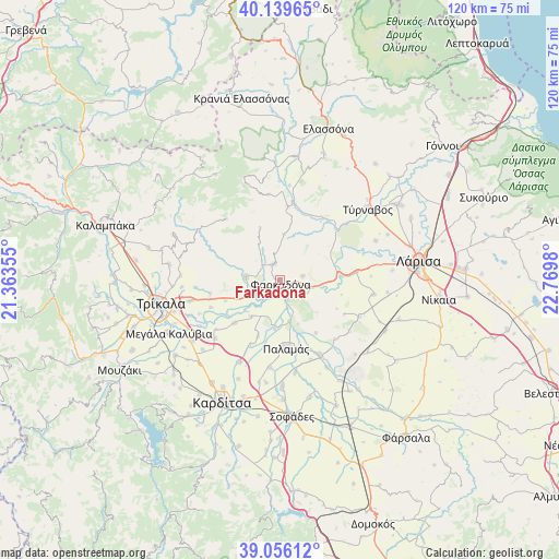
Farkadóna GPS coordinates[2]
39° 36' 0" North, 22° 4' 0.012" East
| Map corner | latitude | longitude |
|---|---|---|
| Upper-left | 40.13965°, | 21.36355° |
| Center: | 39.6°, | 22.06667° |
| Lower-right: | 39.05612°, | 22.7698° |
| Map W x H: | 120.5×120.5 km | = 74.9×74.9mi |
| max Lat: | 41.72048° ⇑40.5% North |
| Farkadóna: | 39.6° |
| min Lat: | ⇓59.5% South 34.8346° |
| min Long | Farkadóna | max Long |
| 19.40494° | 22.06667° | 29.59361° |
| W 29.4%⇐ | ⇒70.6% E |
Elevation
Elevation of Farkadóna is 124 m = 407 ft, and this is 44.9 m = 147 ft below average elevation for this country.
| Max E: |
1439 m = 4721 ft | 38.5% |
| Avg. | 168.9 m = 554 ft | |
| Farkadóna | 124 m = 407 ft | |
Min E: |
0 m = 0 ft | 61.5% |
See also: Greece elevation on elevation.city.
Geographical zone
Farkadóna is located in North temperate zone (between Tropic of Cancer and the Arctic Circle). Distance of this Northern Tropic circle is 1797.2 km =1116.7 mi to South.| Distance of | km | miles | from Farkadóna |
|---|---|---|---|
| North Pole | 5604 | 3482.2 | to North |
| Arctic Circle | 2998.1 | 1862.9 | to North |
| Tropic Cancer | 1797.2 | 1116.7 | to South |
| Equator | 4403.1 | 2736 | to South |


Nearby cities:
15 places around Farkadóna: (largest is in red/bold)
• Faneroméni
15.9 km =9.9 mi,  248°
248°
• Grizáno
3.7 km =2.3 mi,  341°
341°
• Itéa
18.1 km =11.2 mi,  151°
151°
• Kríni
5 km =3.1 mi,  289°
289°
• Marathéa
9.9 km =6.2 mi,  218°
218°
• Mándra
16.7 km =10.4 mi,  84°
84°
• Oichalía
7.5 km =4.7 mi,  277°
277°
• Palamás
14.9 km =9.3 mi,  174°
174°
• Pedinó
13.4 km =8.3 mi,  227°
227°
• Petrotó
9 km =5.6 mi,  260°
260°
• Petróporo
12.6 km =7.8 mi, 250°
• Servotá
17.3 km =10.7 mi, 232°
• Taxiárches
15.2 km =9.4 mi, 259°
• Vlachogiánni
15.9 km =9.9 mi,  6°
6°
• Zárkos
4.9 km =3 mi, 78°
Sources, notices
• [Note1] Compared only with cities in Greece existing in our database
• [Src1] Map data: © OpenStreetMap contributors (CC-BY-SA)
• [Src2] Other city data from geonames.org with taken over terms of usage.
• [Src3] Geographical zone / Annual Mean Temperature by Robert A. Rohde @ Wikipedia
