Zileftí geodata
Zileftí (Thessaly) is a populated place; located in Greece in Europe/Athens (GMT+3) time zone. With population of 596 people, there are 1590 cities with bigger population in this country. Compared to other cities in Greece, 58.9% of cities are located further ↓South; 76% of cities are located further →East and 55.5% of cities have lower elevation than Zileftí. Note1


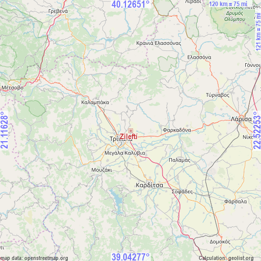
Zileftí GPS coordinates[2]
39° 35' 12.336" North, 21° 49' 9.84" East
| Map corner | latitude | longitude |
|---|---|---|
| Upper-left | 40.12651°, | 21.11628° |
| Center: | 39.58676°, | 21.8194° |
| Lower-right: | 39.04277°, | 22.52253° |
| Map W x H: | 120.5×120.5 km | = 74.9×74.9mi |
| max Lat: | 41.72048° ⇑41.1% North |
| Zileftí: | 39.58676° |
| min Lat: | ⇓58.9% South 34.8346° |
| min Long | Zileftí | max Long |
| 19.40494° | 21.8194° | 29.59361° |
| W 24%⇐ | ⇒76% E |
Elevation
Elevation of Zileftí is 100 m = 328 ft, and this is 68.9 m = 226 ft below average elevation for this country.
| Max E: |
1439 m = 4721 ft | 44.5% |
| Avg. | 168.9 m = 554 ft | |
| Zileftí | 100 m = 328 ft | |
Min E: |
0 m = 0 ft | 55.5% |
See also: Greece elevation on elevation.city.
Geographical zone
Zileftí is located in North temperate zone (between Tropic of Cancer and the Arctic Circle). Distance of this Northern Tropic circle is 1795.7 km =1115.8 mi to South.| Distance of | km | miles | from Zileftí |
|---|---|---|---|
| North Pole | 5605.4 | 3483 | to North |
| Arctic Circle | 2999.5 | 1863.8 | to North |
| Tropic Cancer | 1795.7 | 1115.8 | to South |
| Equator | 4401.6 | 2735 | to South |


Nearby cities:
15 places around Zileftí: (largest is in red/bold)
• Ardáni
5.7 km =3.5 mi,  330°
330°
• Faneroméni
7.8 km =4.8 mi,  124°
124°
• Flamoúli
8.1 km =5 mi,  214°
214°
• Glínos
9.2 km =5.7 mi,  154°
154°
• Megalochóri
3.6 km =2.2 mi, 147°
• Méga Kefalóvryso
7.8 km =4.8 mi,  271°
271°
• Palaiópyrgos
2.4 km =1.5 mi,  355°
355°
• Patouliá
6.9 km =4.3 mi, 146°
• Petróporo
9.7 km =6 mi,  106°
106°
• Plátanos
9.3 km =5.8 mi, 332°
• Pyrgetós
7.2 km =4.5 mi,  238°
238°
• Rizarió
5.5 km =3.4 mi,  196°
196°
• Ráxa
6.7 km =4.2 mi,  293°
293°
• Taxiárches
6.4 km =4 mi,  101°
101°
• Tríkala
5.6 km =3.5 mi,  231°
231°
Sources, notices
• [Note1] Compared only with cities in Greece existing in our database
• [Src1] Map data: © OpenStreetMap contributors (CC-BY-SA)
• [Src2] Other city data from geonames.org with taken over terms of usage.
• [Src3] Geographical zone / Annual Mean Temperature by Robert A. Rohde @ Wikipedia
