Taxiárches geodata
Taxiárches (Thessaly) is a populated place; located in Greece in Europe/Athens (GMT+3) time zone. With population of 1,157 people, there are 862 cities with bigger population in this country. Compared to other cities in Greece, 58.6% of cities are located further ↓South; 74.5% of cities are located further →East and 54% of cities have lower elevation than Taxiárches. Note1


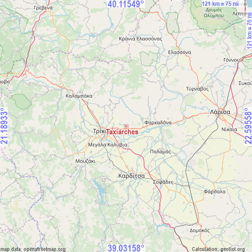
Taxiárches GPS coordinates[2]
39° 34' 32.34" North, 21° 53' 32.82" East
| Map corner | latitude | longitude |
|---|---|---|
| Upper-left | 40.11549°, | 21.18933° |
| Center: | 39.57565°, | 21.89245° |
| Lower-right: | 39.03158°, | 22.59558° |
| Map W x H: | 120.5×120.5 km | = 74.9×74.9mi |
| max Lat: | 41.72048° ⇑41.4% North |
| Taxiárches: | 39.57565° |
| min Lat: | ⇓58.6% South 34.8346° |
| min Long | Taxiárches | max Long |
| 19.40494° | 21.89245° | 29.59361° |
| W 25.5%⇐ | ⇒74.5% E |
Elevation
Elevation of Taxiárches is 96 m = 315 ft, and this is 72.9 m = 239 ft below average elevation for this country.
| Max E: |
1439 m = 4721 ft | 46% |
| Avg. | 168.9 m = 554 ft | |
| Taxiárches | 96 m = 315 ft | |
Min E: |
0 m = 0 ft | 54% |
See also: Greece elevation on elevation.city.
Geographical zone
Taxiárches is located in North temperate zone (between Tropic of Cancer and the Arctic Circle). Distance of this Northern Tropic circle is 1794.5 km =1115.1 mi to South.| Distance of | km | miles | from Taxiárches |
|---|---|---|---|
| North Pole | 5606.7 | 3483.8 | to North |
| Arctic Circle | 3000.8 | 1864.6 | to North |
| Tropic Cancer | 1794.5 | 1115.1 | to South |
| Equator | 4400.4 | 2734.3 | to South |


Nearby cities:
15 places around Taxiárches: (largest is in red/bold)
• Agnanteró
10.7 km =6.6 mi,  200°
200°
• Faneroméni
3.2 km =2 mi,  177°
177°
• Glínos
7.4 km =4.6 mi, 198°
• Marathéa
10.1 km =6.3 mi,  120°
120°
• Megalochóri
4.7 km =2.9 mi,  247°
247°
• Oichalía
8.3 km =5.2 mi,  64°
64°
• Palaiópyrgos
7.4 km =4.6 mi,  299°
299°
• Patouliá
5.1 km =3.2 mi,  207°
207°
• Pedinó
8.2 km =5.1 mi,  141°
141°
• Petrotó
6.2 km =3.9 mi,  79°
79°
• Petróporo
3.4 km =2.1 mi, 117°
• Proástio
9.9 km =6.2 mi,  174°
174°
• Rizarió
8.8 km =5.5 mi,  242°
242°
• Servotá
8 km =5 mi, 170°
• Zileftí
6.4 km =4 mi,  281°
281°
Sources, notices
• [Note1] Compared only with cities in Greece existing in our database
• [Src1] Map data: © OpenStreetMap contributors (CC-BY-SA)
• [Src2] Other city data from geonames.org with taken over terms of usage.
• [Src3] Geographical zone / Annual Mean Temperature by Robert A. Rohde @ Wikipedia
