Arakhnaíon geodata
Arakhnaíon (Peloponnese) is a populated place; located in Greece in Europe/Athens (GMT+3) time zone. With population of 643 people, there are 1505 cities with bigger population in this country. Compared to other cities in Greece, 83.2% of cities are located further ↑North; 53.5% of cities are located further ←West and 93.1% of cities have lower elevation than Arakhnaíon. Note1


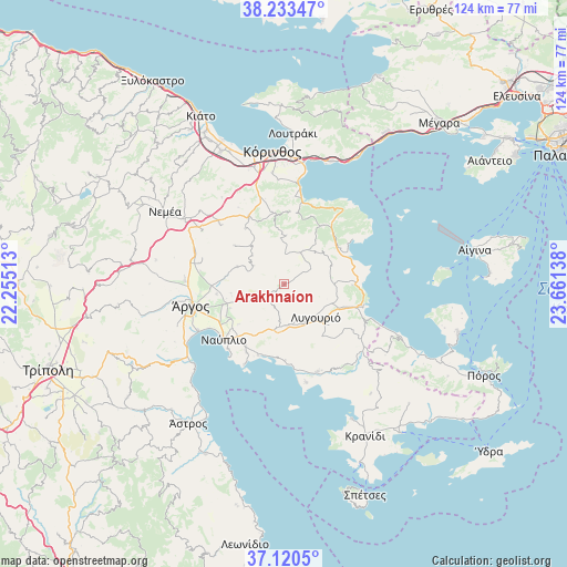
Arakhnaíon GPS coordinates[2]
37° 40' 44.652" North, 22° 57' 29.7" East
| Map corner | latitude | longitude |
|---|---|---|
| Upper-left | 38.23347°, | 22.25513° |
| Center: | 37.67907°, | 22.95825° |
| Lower-right: | 37.1205°, | 23.66138° |
| Map W x H: | 123.8×123.7 km | = 76.9×76.9mi |
| max Lat: | 41.72048° ⇑83.2% North |
| Arakhnaíon: | 37.67907° |
| min Lat: | ⇓16.8% South 34.8346° |
| min Long | Arakhnaíon | max Long |
| 19.40494° | 22.95825° | 29.59361° |
| W 53.5%⇐ | ⇒46.5% E |
Elevation
Elevation of Arakhnaíon is 608 m = 1995 ft, and this is 439.1 m = 1441 ft above average elevation for this country.
| Max E: |
1439 m = 4721 ft | 6.9% |
| Arakhnaíon | 608 m 1995 ft | |
| Avg. | 168.9 m = 554 ft | |
Min E: |
0 m = 0 ft | 93.1% |
See also: Greece elevation on elevation.city.
Geographical zone
Arakhnaíon is located in North temperate zone (between Tropic of Cancer and the Arctic Circle). Distance of this Northern Tropic circle is 1583.6 km =984 mi to South.| Distance of | km | miles | from Arakhnaíon |
|---|---|---|---|
| North Pole | 5817.5 | 3614.8 | to North |
| Arctic Circle | 3211.7 | 1995.7 | to North |
| Tropic Cancer | 1583.6 | 984 | to South |
| Equator | 4189.5 | 2603.2 | to South |


Nearby cities:
15 places around Arakhnaíon: (largest is in red/bold)
• Anífion
15.1 km =9.4 mi,  261°
261°
• Argolikón
15.5 km =9.6 mi,  244°
244°
• Ayía Triás
14.3 km =8.9 mi,  250°
250°
• Klénia
14.8 km =9.2 mi,  324°
324°
• Ligourión
10.2 km =6.3 mi,  136°
136°
• Límnes
7.9 km =4.9 mi,  299°
299°
• Metókhion
8 km =5 mi,  187°
187°
• Mánesis
11.8 km =7.3 mi, 260°
• Néa Epídavros
14.8 km =9.2 mi,  91°
91°
• Néa Tírins
14.5 km =9 mi, 236°
• Panarítis
13 km =8.1 mi, 245°
• Poullakídha
13.1 km =8.1 mi, 255°
• Prósimna
11 km =6.8 mi,  289°
289°
• Sofikón
15.2 km =9.4 mi,  32°
32°
• Áyios Adhrianós
13.3 km =8.3 mi,  228°
228°
Sources, notices
• [Note1] Compared only with cities in Greece existing in our database
• [Src1] Map data: © OpenStreetMap contributors (CC-BY-SA)
• [Src2] Other city data from geonames.org with taken over terms of usage.
• [Src3] Geographical zone / Annual Mean Temperature by Robert A. Rohde @ Wikipedia
