Makhairádhon geodata
Makhairádhon (Ionian Islands) is a populated place; located in Greece in Europe/Athens (GMT+3) time zone. With population of 941 people, there are 1080 cities with bigger population in this country. Compared to other cities in Greece, 81.3% of cities are located further ↑North; 93.7% of cities are located further →East and 57.4% of cities have higher elevation than Makhairádhon. Note1
Administrative division(s):
- Level 1: Ionian Islands
- Level 2: Nomós Zakýnthou
- Level 3: Dimos Zakynthos


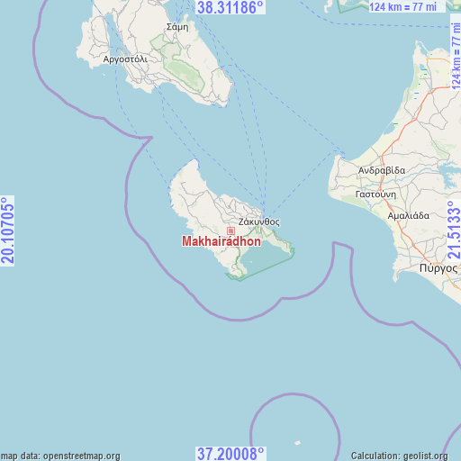
Makhairádhon GPS coordinates[2]
37° 45' 29.016" North, 20° 48' 36.612" East
| Map corner | latitude | longitude |
|---|---|---|
| Upper-left | 38.31186°, | 20.10705° |
| Center: | 37.75806°, | 20.81017° |
| Lower-right: | 37.20008°, | 21.5133° |
| Map W x H: | 123.6×123.6 km | = 76.8×76.8mi |
| max Lat: | 41.72048° ⇑81.3% North |
| Makhairádhon: | 37.75806° |
| min Lat: | ⇓18.7% South 34.8346° |
| min Long | Makhairádhon | max Long |
| 19.40494° | 20.81017° | 29.59361° |
| W 6.3%⇐ | ⇒93.7% E |
Elevation
Elevation of Makhairádhon is 58 m = 190 ft, and this is 110.9 m = 364 ft below average elevation for this country.
| Max E: |
1439 m = 4721 ft | 57.4% |
| Avg. | 168.9 m = 554 ft | |
| Makhairádhon | 58 m = 190 ft | |
Min E: |
0 m = 0 ft | 42.6% |
See also: Greece elevation on elevation.city.
Geographical zone
Makhairádhon is located in North temperate zone (between Tropic of Cancer and the Arctic Circle). Distance of this Northern Tropic circle is 1592.4 km =989.5 mi to South.| Distance of | km | miles | from Makhairádhon |
|---|---|---|---|
| North Pole | 5808.8 | 3609.4 | to North |
| Arctic Circle | 3202.9 | 1990.2 | to North |
| Tropic Cancer | 1592.4 | 989.5 | to South |
| Equator | 4198.3 | 2608.7 | to South |


Nearby cities:
15 places around Makhairádhon: (largest is in red/bold)
• Ambelókipoi
5.5 km =3.4 mi,  89°
89°
• Gaïtánion
6.7 km =4.2 mi,  56°
56°
• Kalipádhon
5.3 km =3.3 mi,  27°
27°
• Kipséli
6.8 km =4.2 mi,  9°
9°
• Laganás
6 km =3.7 mi,  123°
123°
• Lithakiá
4.6 km =2.9 mi,  157°
157°
• Mouzaki
2.7 km =1.7 mi, 155°
• Pantokrátor
3.3 km =2.1 mi,  151°
151°
• Romírion
1.3 km =0.8 mi, 146°
• Sarakinádhon
4.8 km =3 mi,  43°
43°
• Skoulikádo
5.3 km =3.3 mi,  335°
335°
• Tragákion
6.4 km =4 mi,  17°
17°
• Vanáton
5.5 km =3.4 mi, 42°
• Áyios Dhimítrios
4.7 km =2.9 mi,  346°
346°
• Áyios Kírikos
3.8 km =2.4 mi, 28°
Sources, notices
• [Note1] Compared only with cities in Greece existing in our database
• [Src1] Map data: © OpenStreetMap contributors (CC-BY-SA)
• [Src2] Other city data from geonames.org with taken over terms of usage.
• [Src3] Geographical zone / Annual Mean Temperature by Robert A. Rohde @ Wikipedia
