Límnes geodata
Límnes (Peloponnese) is a populated place; located in Greece in Europe/Athens (GMT+3) time zone. With population of 734 people, there are 1356 cities with bigger population in this country. Compared to other cities in Greece, 82.5% of cities are located further ↑North; 51.1% of cities are located further ←West and 90.8% of cities have lower elevation than Límnes. Note1
Administrative division(s):
- Level 1: Peloponnese
- Level 2: Nomós Argolídos
- Level 3: Dimos Argos-Mykines


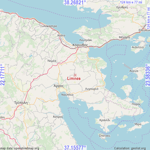
Límnes GPS coordinates[2]
37° 42' 50.688" North, 22° 52' 48.828" East
| Map corner | latitude | longitude |
|---|---|---|
| Upper-left | 38.26821°, | 22.17711° |
| Center: | 37.71408°, | 22.88023° |
| Lower-right: | 37.15577°, | 23.58336° |
| Map W x H: | 123.7×123.7 km | = 76.9×76.9mi |
| max Lat: | 41.72048° ⇑82.5% North |
| Límnes: | 37.71408° |
| min Lat: | ⇓17.5% South 34.8346° |
| min Long | Límnes | max Long |
| 19.40494° | 22.88023° | 29.59361° |
| W 51.1%⇐ | ⇒48.9% E |
Elevation
Elevation of Límnes is 522 m = 1713 ft, and this is 353.1 m = 1158 ft above average elevation for this country.
| Max E: |
1439 m = 4721 ft | 9.2% |
| Límnes | 522 m 1713 ft | |
| Avg. | 168.9 m = 554 ft | |
Min E: |
0 m = 0 ft | 90.8% |
See also: Greece elevation on elevation.city.
Geographical zone
Límnes is located in North temperate zone (between Tropic of Cancer and the Arctic Circle). Distance of this Northern Tropic circle is 1587.5 km =986.4 mi to South.| Distance of | km | miles | from Límnes |
|---|---|---|---|
| North Pole | 5813.6 | 3612.4 | to North |
| Arctic Circle | 3207.8 | 1993.2 | to North |
| Tropic Cancer | 1587.5 | 986.4 | to South |
| Equator | 4193.4 | 2605.7 | to South |


Nearby cities:
15 places around Límnes: (largest is in red/bold)
• Anífion
10.1 km =6.3 mi,  232°
232°
• Arakhnaíon
7.9 km =4.9 mi,  119°
119°
• Argolikón
12.7 km =7.9 mi,  214°
214°
• Athíkia
12.2 km =7.6 mi,  20°
20°
• Ayía Triás
10.8 km =6.7 mi,  217°
217°
• Khiliomódhi
10.7 km =6.6 mi,  355°
355°
• Klénia
8.4 km =5.2 mi,  348°
348°
• Láloukas
12.8 km =8 mi, 221°
• Mánesis
7.6 km =4.7 mi, 218°
• Néa Tírins
12.9 km =8 mi,  204°
204°
• Panarítis
10.5 km =6.5 mi, 208°
• Poullakídha
9.3 km =5.8 mi, 218°
• Prósimna
3.5 km =2.2 mi,  267°
267°
• Áyios Vasílios
11.8 km =7.3 mi,  321°
321°
• Ínachos
12.7 km =7.9 mi,  244°
244°
Sources, notices
• [Note1] Compared only with cities in Greece existing in our database
• [Src1] Map data: © OpenStreetMap contributors (CC-BY-SA)
• [Src2] Other city data from geonames.org with taken over terms of usage.
• [Src3] Geographical zone / Annual Mean Temperature by Robert A. Rohde @ Wikipedia
