Athíkia geodata
Athíkia (Peloponnese) is a populated place; located in Greece in Europe/Athens (GMT+3) time zone. With population of 1,834 people, there are 564 cities with bigger population in this country. Compared to other cities in Greece, 79.5% of cities are located further ↑North; 52.5% of cities are located further ←West and 78.6% of cities have lower elevation than Athíkia. Note1


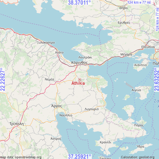
Athíkia GPS coordinates[2]
37° 49' 0.3" North, 22° 55' 45.804" East
| Map corner | latitude | longitude |
|---|---|---|
| Upper-left | 38.37011°, | 22.22627° |
| Center: | 37.81675°, | 22.92939° |
| Lower-right: | 37.25921°, | 23.63252° |
| Map W x H: | 123.5×123.5 km | = 76.7×76.7mi |
| max Lat: | 41.72048° ⇑79.5% North |
| Athíkia: | 37.81675° |
| min Lat: | ⇓20.5% South 34.8346° |
| min Long | Athíkia | max Long |
| 19.40494° | 22.92939° | 29.59361° |
| W 52.5%⇐ | ⇒47.5% E |
Elevation
Elevation of Athíkia is 257 m = 843 ft, and this is 88.1 m = 289 ft above average elevation for this country.
| Max E: |
1439 m = 4721 ft | 21.4% |
| Athíkia | 257 m 843 ft | |
| Avg. | 168.9 m = 554 ft | |
Min E: |
0 m = 0 ft | 78.6% |
See also: Greece elevation on elevation.city.
Geographical zone
Athíkia is located in North temperate zone (between Tropic of Cancer and the Arctic Circle). Distance of this Northern Tropic circle is 1598.9 km =993.5 mi to South.| Distance of | km | miles | from Athíkia |
|---|---|---|---|
| North Pole | 5802.2 | 3605.3 | to North |
| Arctic Circle | 3196.3 | 1986.1 | to North |
| Tropic Cancer | 1598.9 | 993.5 | to South |
| Equator | 4204.8 | 2612.7 | to South |


Nearby cities:
15 places around Athíkia: (largest is in red/bold)
• Archaío Limáni
13.1 km =8.1 mi,  345°
345°
• Arkhaía Kórinthos
11.1 km =6.9 mi,  338°
338°
• Examília
9 km =5.6 mi,  359°
359°
• Isthmía
12.6 km =7.8 mi,  31°
31°
• Khiliomódhi
5.3 km =3.3 mi,  262°
262°
• Klénia
6.8 km =4.2 mi,  241°
241°
• Kyrás Vrýsi
11.8 km =7.3 mi, 25°
• Káto Almyrí
7.4 km =4.6 mi,  61°
61°
• Káto Examília
10.1 km =6.3 mi,  5°
5°
• Loutrá Oraías Elénis
7.9 km =4.9 mi,  47°
47°
• Límnes
12.2 km =7.6 mi,  200°
200°
• Sofikón
11.1 km =6.9 mi,  103°
103°
• Solomós
7.5 km =4.7 mi,  332°
332°
• Xilokériza
7.4 km =4.6 mi, 8°
• Áyios Vasílios
11.8 km =7.3 mi, 259°
Sources, notices
• [Note1] Compared only with cities in Greece existing in our database
• [Src1] Map data: © OpenStreetMap contributors (CC-BY-SA)
• [Src2] Other city data from geonames.org with taken over terms of usage.
• [Src3] Geographical zone / Annual Mean Temperature by Robert A. Rohde @ Wikipedia
