Káto Glykóvrysi geodata
Káto Glykóvrysi (Peloponnese) is a populated place; located in Greece in Europe/Athens (GMT+3) time zone. With population of 1,753 people, there are 583 cities with bigger population in this country. Compared to other cities in Greece, 91.1% of cities are located further ↑North; 52.5% of cities are located further →East and 65.2% of cities have higher elevation than Káto Glykóvrysi. Note1


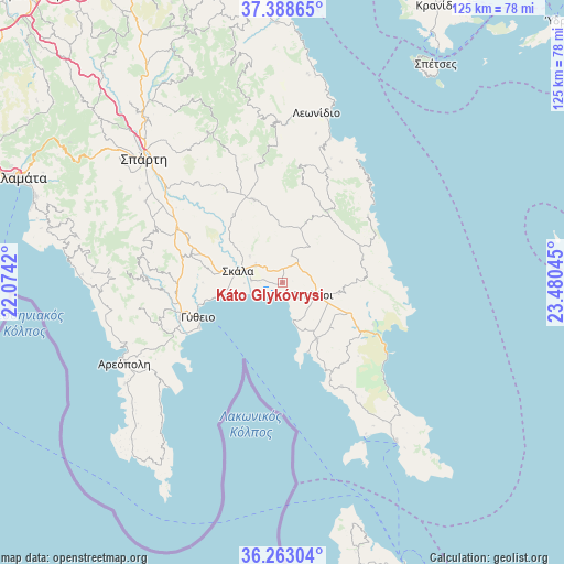
Káto Glykóvrysi GPS coordinates[2]
36° 49' 40.476" North, 22° 46' 38.352" East
| Map corner | latitude | longitude |
|---|---|---|
| Upper-left | 37.38865°, | 22.0742° |
| Center: | 36.82791°, | 22.77732° |
| Lower-right: | 36.26304°, | 23.48045° |
| Map W x H: | 125.2×125.2 km | = 77.8×77.8mi |
| max Lat: | 41.72048° ⇑91.1% North |
| Káto Glykóvrysi: | 36.82791° |
| min Lat: | ⇓8.9% South 34.8346° |
| min Long | Káto Glykóvry | max Long |
| 19.40494° | 22.77732° | 29.59361° |
| W 47.5%⇐ | ⇒52.5% E |
Elevation
Elevation of Káto Glykóvrysi is 39 m = 128 ft, and this is 129.9 m = 426 ft below average elevation for this country.
| Max E: |
1439 m = 4721 ft | 65.2% |
| Avg. | 168.9 m = 554 ft | |
| Káto Glykóvrysi | 39 m = 128 ft | |
Min E: |
0 m = 0 ft | 34.8% |
See also: Greece elevation on elevation.city.
Geographical zone
Káto Glykóvrysi is located in North temperate zone (between Tropic of Cancer and the Arctic Circle). Distance of this Northern Tropic circle is 1489 km =925.2 mi to South.| Distance of | km | miles | from Káto Glykóvrysi |
|---|---|---|---|
| North Pole | 5912.2 | 3673.7 | to North |
| Arctic Circle | 3306.3 | 2054.4 | to North |
| Tropic Cancer | 1489 | 925.2 | to South |
| Equator | 4094.9 | 2544.5 | to South |


Nearby cities:
15 places around Káto Glykóvrysi: (largest is in red/bold)
• Areópoli
39.6 km =24.6 mi,  242°
242°
• Asopós
12.9 km =8 mi,  147°
147°
• Elafónisos
39.8 km =24.7 mi, 153°
• Geráki
19.3 km =12 mi,  341°
341°
• Géfyra
27.8 km =17.3 mi,  124°
124°
• Gýtheio
20.6 km =12.8 mi,  246°
246°
• Krokeés
21.4 km =13.3 mi,  286°
286°
• Leonídio
38.4 km =23.9 mi,  10°
10°
• Moláoi
7 km =4.3 mi,  108°
108°
• Poúlithra
32.8 km =20.4 mi,  17°
17°
• Skála
10.1 km =6.3 mi,  284°
284°
• Sykiá
16.4 km =10.2 mi, 115°
• Vlachiótis
7.2 km =4.5 mi,  300°
300°
• Xirokámbion
32.4 km =20.1 mi, 296°
• Élos
7.1 km =4.4 mi,  274°
274°
Sources, notices
• [Note1] Compared only with cities in Greece existing in our database
• [Src1] Map data: © OpenStreetMap contributors (CC-BY-SA)
• [Src2] Other city data from geonames.org with taken over terms of usage.
• [Src3] Geographical zone / Annual Mean Temperature by Robert A. Rohde @ Wikipedia
