Chalkeió geodata
Chalkeió (North Aegean) is a populated place; located in Greece in Europe/Athens (GMT+3) time zone. With population of 950 people, there are 1073 cities with bigger population in this country. Compared to other cities in Greece, 65% of cities are located further ↑North; 93.7% of cities are located further ←West and 57.4% of cities have higher elevation than Chalkeió. Note1


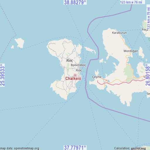
Chalkeió GPS coordinates[2]
38° 20' 0.06" North, 26° 5' 54.42" East
| Map corner | latitude | longitude |
|---|---|---|
| Upper-left | 38.88279°, | 25.39533° |
| Center: | 38.33335°, | 26.09845° |
| Lower-right: | 37.77971°, | 26.80158° |
| Map W x H: | 122.7×122.7 km | = 76.2×76.2mi |
| max Lat: | 41.72048° ⇑65% North |
| Chalkeió: | 38.33335° |
| min Lat: | ⇓35% South 34.8346° |
| min Long | Chalkeió | max Long |
| 19.40494° | 26.09845° | 29.59361° |
| W 93.7%⇐ | ⇒6.3% E |
Elevation
Elevation of Chalkeió is 58 m = 190 ft, and this is 110.9 m = 364 ft below average elevation for this country.
| Max E: |
1439 m = 4721 ft | 57.4% |
| Avg. | 168.9 m = 554 ft | |
| Chalkeió | 58 m = 190 ft | |
Min E: |
0 m = 0 ft | 42.6% |
See also: Greece elevation on elevation.city.
Geographical zone
Chalkeió is located in North temperate zone (between Tropic of Cancer and the Arctic Circle). Distance of this Northern Tropic circle is 1656.3 km =1029.2 mi to South.| Distance of | km | miles | from Chalkeió |
|---|---|---|---|
| North Pole | 5744.8 | 3569.7 | to North |
| Arctic Circle | 3138.9 | 1950.4 | to North |
| Tropic Cancer | 1656.3 | 1029.2 | to South |
| Equator | 4262.3 | 2648.5 | to South |


Nearby cities:
15 places around Chalkeió: (largest is in red/bold)
• Chios
5.2 km =3.2 mi,  40°
40°
• Kalamotí
12 km =7.5 mi,  202°
202°
• Kallimasiá
4.4 km =2.7 mi,  175°
175°
• Kardámyla
21.7 km =13.5 mi,  358°
358°
• Karyés
6.4 km =4 mi, 358°
• Lagkáda
16.3 km =10.1 mi,  7°
7°
• Neochóri
3.1 km =1.9 mi,  155°
155°
• Nénita
10.5 km =6.5 mi, 182°
• Oinoússes
22.9 km =14.2 mi,  28°
28°
• Pyrgíon
14.7 km =9.1 mi,  215°
215°
• Sykiáda
14.7 km =9.1 mi, 8°
• Tholopotámi
4.8 km =3 mi,  207°
207°
• Thymianá
3.6 km =2.2 mi,  125°
125°
• Vrontádos
8.8 km =5.5 mi,  17°
17°
• Ágios Geórgios Sykoúsis
4 km =2.5 mi,  246°
246°
Sources, notices
• [Note1] Compared only with cities in Greece existing in our database
• [Src1] Map data: © OpenStreetMap contributors (CC-BY-SA)
• [Src2] Other city data from geonames.org with taken over terms of usage.
• [Src3] Geographical zone / Annual Mean Temperature by Robert A. Rohde @ Wikipedia
