Kallimasiá geodata
Kallimasiá (North Aegean) is a populated place; located in Greece in Europe/Athens (GMT+3) time zone. With population of 958 people, there are 1065 cities with bigger population in this country. Compared to other cities in Greece, 66.4% of cities are located further ↑North; 93.7% of cities are located further ←West and 67% of cities have lower elevation than Kallimasiá. Note1


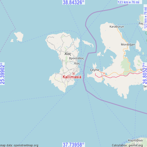
Kallimasiá GPS coordinates[2]
38° 17' 36.672" North, 26° 6' 7.704" East
| Map corner | latitude | longitude |
|---|---|---|
| Upper-left | 38.84326°, | 25.39902° |
| Center: | 38.29352°, | 26.10214° |
| Lower-right: | 37.73958°, | 26.80527° |
| Map W x H: | 122.7×122.7 km | = 76.2×76.2mi |
| max Lat: | 41.72048° ⇑66.4% North |
| Kallimasiá: | 38.29352° |
| min Lat: | ⇓33.6% South 34.8346° |
| min Long | Kallimasiá | max Long |
| 19.40494° | 26.10214° | 29.59361° |
| W 93.7%⇐ | ⇒6.3% E |
Elevation
Elevation of Kallimasiá is 147 m = 482 ft, and this is 21.9 m = 72 ft below average elevation for this country.
| Max E: |
1439 m = 4721 ft | 33% |
| Avg. | 168.9 m = 554 ft | |
| Kallimasiá | 147 m = 482 ft | |
Min E: |
0 m = 0 ft | 67% |
See also: Greece elevation on elevation.city.
Geographical zone
Kallimasiá is located in North temperate zone (between Tropic of Cancer and the Arctic Circle). Distance of this Northern Tropic circle is 1651.9 km =1026.4 mi to South.| Distance of | km | miles | from Kallimasiá |
|---|---|---|---|
| North Pole | 5749.2 | 3572.4 | to North |
| Arctic Circle | 3143.3 | 1953.2 | to North |
| Tropic Cancer | 1651.9 | 1026.4 | to South |
| Equator | 4257.8 | 2645.7 | to South |


Nearby cities:
15 places around Kallimasiá: (largest is in red/bold)
• Chalkeió
4.4 km =2.7 mi,  355°
355°
• Chios
8.9 km =5.5 mi,  20°
20°
• Kalamotí
8.3 km =5.2 mi,  216°
216°
• Kardámyla
26.1 km =16.2 mi, 358°
• Karyés
10.9 km =6.8 mi, 357°
• Lagkáda
20.6 km =12.8 mi,  5°
5°
• Neochóri
1.8 km =1.1 mi,  32°
32°
• Nénita
6.1 km =3.8 mi,  187°
187°
• Oinoússes
26.7 km =16.6 mi, 23°
• Pyrgíon
11.6 km =7.2 mi,  230°
230°
• Sykiáda
19.1 km =11.9 mi, 5°
• Tholopotámi
2.6 km =1.6 mi,  274°
274°
• Thymianá
3.5 km =2.2 mi,  48°
48°
• Vrontádos
13 km =8.1 mi, 10°
• Ágios Geórgios Sykoúsis
4.8 km =3 mi,  305°
305°
Sources, notices
• [Note1] Compared only with cities in Greece existing in our database
• [Src1] Map data: © OpenStreetMap contributors (CC-BY-SA)
• [Src2] Other city data from geonames.org with taken over terms of usage.
• [Src3] Geographical zone / Annual Mean Temperature by Robert A. Rohde @ Wikipedia
