Kastélli geodata
Kastélli (Crete) is a seat of a third-order administrative division; located in Greece in Europe/Athens (GMT+3) time zone. With population of 1,828 people, there are 565 cities with bigger population in this country. Compared to other cities in Greece, 97.8% of cities are located further ↑North; 89.7% of cities are located further ←West and 83.2% of cities have lower elevation than Kastélli. Note1


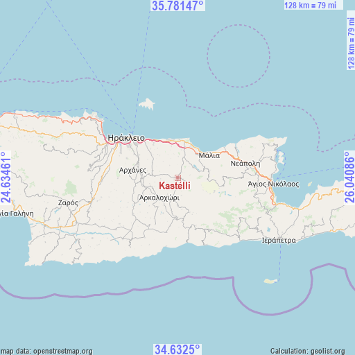
Kastélli GPS coordinates[2]
35° 12' 32.472" North, 25° 20' 15.828" East
| Map corner | latitude | longitude |
|---|---|---|
| Upper-left | 35.78147°, | 24.63461° |
| Center: | 35.20902°, | 25.33773° |
| Lower-right: | 34.6325°, | 26.04086° |
| Map W x H: | 127.8×127.8 km | = 79.4×79.4mi |
| max Lat: | 41.72048° ⇑97.8% North |
| Kastélli: | 35.20902° |
| min Lat: | ⇓2.2% South 34.8346° |
| min Long | Kastélli | max Long |
| 19.40494° | 25.33773° | 29.59361° |
| W 89.7%⇐ | ⇒10.3% E |
Elevation
Elevation of Kastélli is 338 m = 1109 ft, and this is 169.1 m = 555 ft above average elevation for this country.
| Max E: |
1439 m = 4721 ft | 16.8% |
| Kastélli | 338 m 1109 ft | |
| Avg. | 168.9 m = 554 ft | |
Min E: |
0 m = 0 ft | 83.2% |
See also: Greece elevation on elevation.city.
Geographical zone
Kastélli is located in North temperate zone (between Tropic of Cancer and the Arctic Circle). Distance of this Northern Tropic circle is 1309 km =813.4 mi to South.| Distance of | km | miles | from Kastélli |
|---|---|---|---|
| North Pole | 6092.2 | 3785.5 | to North |
| Arctic Circle | 3486.3 | 2166.3 | to North |
| Tropic Cancer | 1309 | 813.4 | to South |
| Equator | 3914.9 | 2432.6 | to South |


Nearby cities:
15 places around Kastélli: (largest is in red/bold)
• Arkalochóri
9.6 km =6 mi,  223°
223°
• Eliá
14.2 km =8.8 mi,  317°
317°
• Episkopí
10.5 km =6.5 mi,  300°
300°
• Goúrnes
14.1 km =8.8 mi,  337°
337°
• Goúves
11.5 km =7.1 mi,  348°
348°
• Khersónisos
11.4 km =7.1 mi,  15°
15°
• Káto Goúves
13.6 km =8.5 mi, 350°
• Limín Khersonísou
13.6 km =8.5 mi, 21°
• Mokhós
9.8 km =6.1 mi,  52°
52°
• Mália
14.1 km =8.8 mi, 53°
• Stalís
12.7 km =7.9 mi,  42°
42°
• Thrapsanón
5.7 km =3.5 mi,  245°
245°
• Tzermiádon
13.8 km =8.6 mi,  94°
94°
• Vatheianós Kámpos
15.1 km =9.4 mi,  325°
325°
• Áyiai Paraskiaí
12.1 km =7.5 mi,  270°
270°
Sources, notices
• [Note1] Compared only with cities in Greece existing in our database
• [Src1] Map data: © OpenStreetMap contributors (CC-BY-SA)
• [Src2] Other city data from geonames.org with taken over terms of usage.
• [Src3] Geographical zone / Annual Mean Temperature by Robert A. Rohde @ Wikipedia
