Thrapsanón geodata
Thrapsanón (Crete) is a populated place; located in Greece in Europe/Athens (GMT+3) time zone. With population of 1,499 people, there are 661 cities with bigger population in this country. Compared to other cities in Greece, 98.3% of cities are located further ↑North; 89.2% of cities are located further ←West and 83.6% of cities have lower elevation than Thrapsanón. Note1


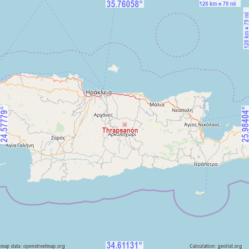
Thrapsanón GPS coordinates[2]
35° 11' 16.728" North, 25° 16' 51.276" East
| Map corner | latitude | longitude |
|---|---|---|
| Upper-left | 35.76058°, | 24.57779° |
| Center: | 35.18798°, | 25.28091° |
| Lower-right: | 34.61131°, | 25.98404° |
| Map W x H: | 127.8×127.8 km | = 79.4×79.4mi |
| max Lat: | 41.72048° ⇑98.3% North |
| Thrapsanón: | 35.18798° |
| min Lat: | ⇓1.7% South 34.8346° |
| min Long | Thrapsanón | max Long |
| 19.40494° | 25.28091° | 29.59361° |
| W 89.2%⇐ | ⇒10.8% E |
Elevation
Elevation of Thrapsanón is 350 m = 1148 ft, and this is 181.1 m = 594 ft above average elevation for this country.
| Max E: |
1439 m = 4721 ft | 16.4% |
| Thrapsanón | 350 m 1148 ft | |
| Avg. | 168.9 m = 554 ft | |
Min E: |
0 m = 0 ft | 83.6% |
See also: Greece elevation on elevation.city.
Geographical zone
Thrapsanón is located in North temperate zone (between Tropic of Cancer and the Arctic Circle). Distance of this Northern Tropic circle is 1306.6 km =811.9 mi to South.| Distance of | km | miles | from Thrapsanón |
|---|---|---|---|
| North Pole | 6094.5 | 3786.9 | to North |
| Arctic Circle | 3488.6 | 2167.7 | to North |
| Tropic Cancer | 1306.6 | 811.9 | to South |
| Equator | 3912.5 | 2431.1 | to South |


Nearby cities:
15 places around Thrapsanón: (largest is in red/bold)
• Ano Arhanes
11.5 km =7.1 mi,  295°
295°
• Arkalochóri
4.8 km =3 mi,  196°
196°
• Eliá
13.6 km =8.5 mi,  340°
340°
• Episkopí
8.6 km =5.3 mi,  332°
332°
• Goúrnes
15.4 km =9.6 mi,  358°
358°
• Goúves
13.9 km =8.6 mi,  12°
12°
• Kastélli
5.7 km =3.5 mi,  65°
65°
• Khersónisos
15.7 km =9.8 mi,  31°
31°
• Kokkíni Cháni
15.7 km =9.8 mi,  352°
352°
• Káto Goúves
16 km =9.9 mi, 10°
• Mokhós
15.4 km =9.6 mi,  56°
56°
• Skalánion
13.6 km =8.5 mi,  320°
320°
• Vasilíai
15.9 km =9.9 mi,  305°
305°
• Vatheianós Kámpos
15.2 km =9.4 mi, 347°
• Áyiai Paraskiaí
7.3 km =4.5 mi,  289°
289°
Sources, notices
• [Note1] Compared only with cities in Greece existing in our database
• [Src1] Map data: © OpenStreetMap contributors (CC-BY-SA)
• [Src2] Other city data from geonames.org with taken over terms of usage.
• [Src3] Geographical zone / Annual Mean Temperature by Robert A. Rohde @ Wikipedia
