Arkalochóri geodata
Arkalochóri (Crete) is a populated place; located in Greece in Europe/Athens (GMT+3) time zone. With population of 3,537 people, there are 303 cities with bigger population in this country. Compared to other cities in Greece, 98.4% of cities are located further ↑North; 89.1% of cities are located further ←West and 85.4% of cities have lower elevation than Arkalochóri. Note1


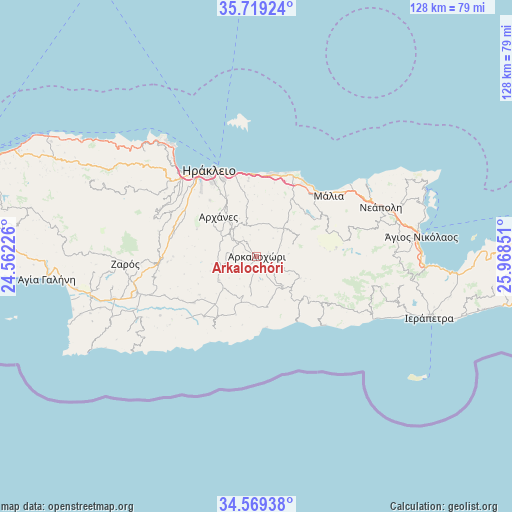
Arkalochóri GPS coordinates[2]
35° 8' 46.824" North, 25° 15' 55.368" East
| Map corner | latitude | longitude |
|---|---|---|
| Upper-left | 35.71924°, | 24.56226° |
| Center: | 35.14634°, | 25.26538° |
| Lower-right: | 34.56938°, | 25.96851° |
| Map W x H: | 127.9×127.9 km | = 79.5×79.5mi |
| max Lat: | 41.72048° ⇑98.4% North |
| Arkalochóri: | 35.14634° |
| min Lat: | ⇓1.6% South 34.8346° |
| min Long | Arkalochóri | max Long |
| 19.40494° | 25.26538° | 29.59361° |
| W 89.1%⇐ | ⇒10.9% E |
Elevation
Elevation of Arkalochóri is 386 m = 1266 ft, and this is 217.1 m = 712 ft above average elevation for this country.
| Max E: |
1439 m = 4721 ft | 14.6% |
| Arkalochóri | 386 m 1266 ft | |
| Avg. | 168.9 m = 554 ft | |
Min E: |
0 m = 0 ft | 85.4% |
See also: Greece elevation on elevation.city.
Geographical zone
Arkalochóri is located in North temperate zone (between Tropic of Cancer and the Arctic Circle). Distance of this Northern Tropic circle is 1302 km =809 mi to South.| Distance of | km | miles | from Arkalochóri |
|---|---|---|---|
| North Pole | 6099.2 | 3789.9 | to North |
| Arctic Circle | 3493.3 | 2170.6 | to North |
| Tropic Cancer | 1302 | 809 | to South |
| Equator | 3907.9 | 2428.3 | to South |


Nearby cities:
15 places around Arkalochóri: (largest is in red/bold)
• Ano Arhanes
13.2 km =8.2 mi,  317°
317°
• Asímion
19.4 km =12.1 mi,  233°
233°
• Eliá
17.7 km =11 mi,  350°
350°
• Episkopí
12.6 km =7.8 mi, 348°
• Goúrnes
20 km =12.4 mi,  3°
3°
• Goúves
18.8 km =11.7 mi,  13°
13°
• Kastélli
9.6 km =6 mi,  43°
43°
• Mokhós
19.4 km =12.1 mi,  47°
47°
• Profítis Ilías
16.4 km =10.2 mi,  293°
293°
• Pýrgos
18.7 km =11.6 mi,  213°
213°
• Skalánion
16.7 km =10.4 mi,  334°
334°
• Thrapsanón
4.8 km =3 mi,  16°
16°
• Vasilíai
18 km =11.2 mi, 320°
• Vatheianós Kámpos
19.5 km =12.1 mi, 354°
• Áyiai Paraskiaí
8.9 km =5.5 mi, 321°
Sources, notices
• [Note1] Compared only with cities in Greece existing in our database
• [Src1] Map data: © OpenStreetMap contributors (CC-BY-SA)
• [Src2] Other city data from geonames.org with taken over terms of usage.
• [Src3] Geographical zone / Annual Mean Temperature by Robert A. Rohde @ Wikipedia
