Karavómilos geodata
Karavómilos (Central Greece) is a populated place; located in Greece in Europe/Athens (GMT+3) time zone. With population of 634 people, there are 1521 cities with bigger population in this country. Compared to other cities in Greece, 56.1% of cities are located further ↑North; 55% of cities are located further →East and 76.9% of cities have higher elevation than Karavómilos. Note1
Administrative division(s):
- Level 1: Central Greece
- Level 2: Nomós Fthiótidos
- Level 3: Dimos Stylida


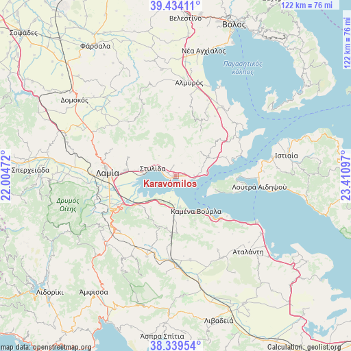
Karavómilos GPS coordinates[2]
38° 53' 20.148" North, 22° 42' 28.224" East
| Map corner | latitude | longitude |
|---|---|---|
| Upper-left | 39.43411°, | 22.00472° |
| Center: | 38.88893°, | 22.70784° |
| Lower-right: | 38.33954°, | 23.41097° |
| Map W x H: | 121.7×121.7 km | = 75.6×75.6mi |
| max Lat: | 41.72048° ⇑56.1% North |
| Karavómilos: | 38.88893° |
| min Lat: | ⇓43.9% South 34.8346° |
| min Long | Karavómilos | max Long |
| 19.40494° | 22.70784° | 29.59361° |
| W 45%⇐ | ⇒55% E |
Elevation
Elevation of Karavómilos is 21 m = 69 ft, and this is 147.9 m = 485 ft below average elevation for this country.
| Max E: |
1439 m = 4721 ft | 76.9% |
| Avg. | 168.9 m = 554 ft | |
| Karavómilos | 21 m = 69 ft | |
Min E: |
0 m = 0 ft | 23.1% |
See also: Greece elevation on elevation.city.
Geographical zone
Karavómilos is located in North temperate zone (between Tropic of Cancer and the Arctic Circle). Distance of this Northern Tropic circle is 1718.1 km =1067.6 mi to South.| Distance of | km | miles | from Karavómilos |
|---|---|---|---|
| North Pole | 5683 | 3531.3 | to North |
| Arctic Circle | 3077.1 | 1912 | to North |
| Tropic Cancer | 1718.1 | 1067.6 | to South |
| Equator | 4324 | 2686.8 | to South |


Nearby cities:
15 places around Karavómilos: (largest is in red/bold)
• Agía Paraskeví Lamiéon
18.9 km =11.7 mi,  274°
274°
• Akhinós
1.5 km =0.9 mi,  73°
73°
• Anthíli
20.3 km =12.6 mi,  257°
257°
• Kainoúryion
10.8 km =6.7 mi,  172°
172°
• Kaména Voúrla
14 km =8.7 mi,  151°
151°
• Megáli Vrísi
20.1 km =12.5 mi, 271°
• Mólos
10.3 km =6.4 mi,  211°
211°
• Paralía Rachón
6.1 km =3.8 mi,  97°
97°
• Pelasgía
13.2 km =8.2 mi,  60°
60°
• Rengínion
18.8 km =11.7 mi,  179°
179°
• Rákhai
6.4 km =4 mi,  88°
88°
• Stylída
8.5 km =5.3 mi,  291°
291°
• Ágios Geórgios Lichádos
16 km =9.9 mi,  110°
110°
• Áyios Konstandínos
19.7 km =12.2 mi,  138°
138°
• Áyios Serafím
9.8 km =6.1 mi, 181°
Sources, notices
• [Note1] Compared only with cities in Greece existing in our database
• [Src1] Map data: © OpenStreetMap contributors (CC-BY-SA)
• [Src2] Other city data from geonames.org with taken over terms of usage.
• [Src3] Geographical zone / Annual Mean Temperature by Robert A. Rohde @ Wikipedia
