Rákhai geodata
Rákhai (Central Greece) is a populated place; located in Greece in Europe/Athens (GMT+3) time zone. With population of 593 people, there are 1597 cities with bigger population in this country. Compared to other cities in Greece, 56% of cities are located further ↑North; 52.2% of cities are located further →East and 58.4% of cities have lower elevation than Rákhai. Note1
Administrative division(s):
- Level 1: Central Greece
- Level 2: Nomós Fthiótidos
- Level 3: Dimos Stylida


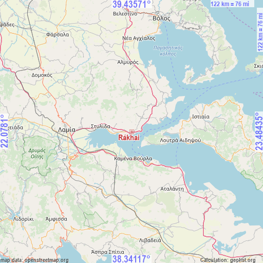
Rákhai GPS coordinates[2]
38° 53' 25.98" North, 22° 46' 52.392" East
| Map corner | latitude | longitude |
|---|---|---|
| Upper-left | 39.43571°, | 22.0781° |
| Center: | 38.89055°, | 22.78122° |
| Lower-right: | 38.34117°, | 23.48435° |
| Map W x H: | 121.7×121.7 km | = 75.6×75.6mi |
| max Lat: | 41.72048° ⇑56% North |
| Rákhai: | 38.89055° |
| min Lat: | ⇓44% South 34.8346° |
| min Long | Rákhai | max Long |
| 19.40494° | 22.78122° | 29.59361° |
| W 47.8%⇐ | ⇒52.2% E |
Elevation
Elevation of Rákhai is 111 m = 364 ft, and this is 57.9 m = 190 ft below average elevation for this country.
| Max E: |
1439 m = 4721 ft | 41.6% |
| Avg. | 168.9 m = 554 ft | |
| Rákhai | 111 m = 364 ft | |
Min E: |
0 m = 0 ft | 58.4% |
See also: Greece elevation on elevation.city.
Geographical zone
Rákhai is located in North temperate zone (between Tropic of Cancer and the Arctic Circle). Distance of this Northern Tropic circle is 1718.3 km =1067.7 mi to South.| Distance of | km | miles | from Rákhai |
|---|---|---|---|
| North Pole | 5682.8 | 3531.1 | to North |
| Arctic Circle | 3077 | 1912 | to North |
| Tropic Cancer | 1718.3 | 1067.7 | to South |
| Equator | 4324.2 | 2686.9 | to South |


Nearby cities:
15 places around Rákhai: (largest is in red/bold)
• Akhinós
4.9 km =3 mi,  272°
272°
• Akhíllio
20.1 km =12.5 mi,  50°
50°
• Giáltra
17.1 km =10.6 mi,  100°
100°
• Glífa
17.5 km =10.9 mi,  66°
66°
• Kainoúryion
11.9 km =7.4 mi,  204°
204°
• Kaména Voúrla
12.5 km =7.8 mi,  178°
178°
• Karavómilos
6.4 km =4 mi, 268°
• Mólos
14.8 km =9.2 mi,  232°
232°
• Paralía Rachón
1 km =0.6 mi, 199°
• Pelasgía
8.2 km =5.1 mi,  38°
38°
• Rengínion
20 km =12.4 mi, 197°
• Stylída
14.5 km =9 mi,  281°
281°
• Ágios Geórgios Lichádos
10.4 km =6.5 mi,  124°
124°
• Áyios Konstandínos
16.3 km =10.1 mi,  156°
156°
• Áyios Serafím
12 km =7.5 mi,  213°
213°
Sources, notices
• [Note1] Compared only with cities in Greece existing in our database
• [Src1] Map data: © OpenStreetMap contributors (CC-BY-SA)
• [Src2] Other city data from geonames.org with taken over terms of usage.
• [Src3] Geographical zone / Annual Mean Temperature by Robert A. Rohde @ Wikipedia
