Folégandros geodata
Folégandros (South Aegean) is a seat of a third-order administrative division; located in Greece in Europe/Athens (GMT+3) time zone. With population of 667 people, there are 1468 cities with bigger population in this country. Compared to other cities in Greece, 92.3% of cities are located further ↑North; 86.4% of cities are located further ←West and 74.6% of cities have lower elevation than Folégandros. Note1
Administrative division(s):
- Level 1: South Aegean
- Level 2: Nomós Kykládon
- Level 3: Dimos Folegandros


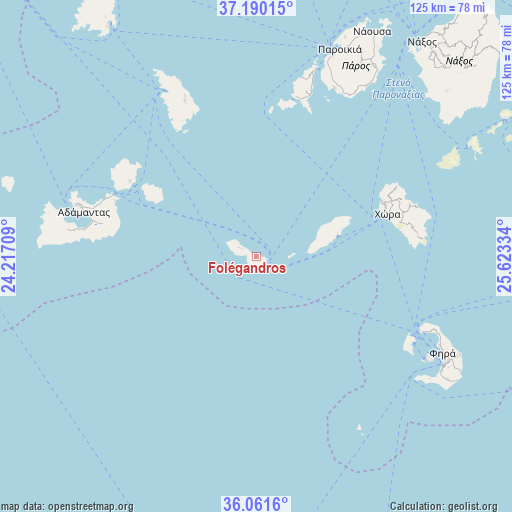
Folégandros GPS coordinates[2]
36° 37' 40.584" North, 24° 55' 12.756" East
| Map corner | latitude | longitude |
|---|---|---|
| Upper-left | 37.19015°, | 24.21709° |
| Center: | 36.62794°, | 24.92021° |
| Lower-right: | 36.0616°, | 25.62334° |
| Map W x H: | 125.5×125.5 km | = 78×78mi |
| max Lat: | 41.72048° ⇑92.3% North |
| Folégandros: | 36.62794° |
| min Lat: | ⇓7.7% South 34.8346° |
| min Long | Folégandros | max Long |
| 19.40494° | 24.92021° | 29.59361° |
| W 86.4%⇐ | ⇒13.6% E |
Elevation
Elevation of Folégandros is 206 m = 676 ft, and this is 37.1 m = 122 ft above average elevation for this country.
| Max E: |
1439 m = 4721 ft | 25.4% |
| Folégandros | 206 m 676 ft | |
| Avg. | 168.9 m = 554 ft | |
Min E: |
0 m = 0 ft | 74.6% |
See also: Greece elevation on elevation.city.
Geographical zone
Folégandros is located in North temperate zone (between Tropic of Cancer and the Arctic Circle). Distance of this Northern Tropic circle is 1466.7 km =911.4 mi to South.| Distance of | km | miles | from Folégandros |
|---|---|---|---|
| North Pole | 5934.4 | 3687.5 | to North |
| Arctic Circle | 3328.5 | 2068.2 | to North |
| Tropic Cancer | 1466.7 | 911.4 | to South |
| Equator | 4072.6 | 2530.6 | to South |


Nearby cities:
15 places around Folégandros: (largest is in red/bold)
• Adámas
43.6 km =27.1 mi,  284°
284°
• Antíparos
48 km =29.8 mi,  17°
17°
• Apollonía
42.2 km =26.2 mi,  335°
335°
• Artemón
43 km =26.7 mi, 336°
• Firá
51.1 km =31.8 mi,  116°
116°
• Kímolos
35.8 km =22.2 mi,  300°
300°
• Mesariá
53.6 km =33.3 mi, 118°
• Mílos
45.9 km =28.5 mi,  286°
286°
• Oía
44.7 km =27.8 mi,  114°
114°
• Pláka
46.2 km =28.7 mi, 286°
• Péran Triovasálos
44.9 km =27.9 mi, 286°
• Síkinos
19.3 km =12 mi,  65°
65°
• Triovasálos
45.3 km =28.1 mi, 286°
• Trypití
45.6 km =28.3 mi, 285°
• Íos
34.4 km =21.4 mi, 70°
Sources, notices
• [Note1] Compared only with cities in Greece existing in our database
• [Src1] Map data: © OpenStreetMap contributors (CC-BY-SA)
• [Src2] Other city data from geonames.org with taken over terms of usage.
• [Src3] Geographical zone / Annual Mean Temperature by Robert A. Rohde @ Wikipedia
