Triovasálos geodata
Triovasálos (South Aegean) is a populated place; located in Greece in Europe/Athens (GMT+3) time zone. With population of 838 people, there are 1215 cities with bigger population in this country. Compared to other cities in Greece, 91.7% of cities are located further ↑North; 83.1% of cities are located further ←West and 63.9% of cities have lower elevation than Triovasálos. Note1


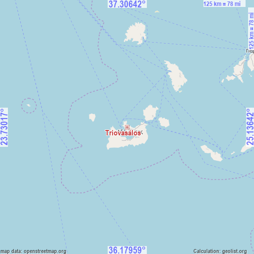
Triovasálos GPS coordinates[2]
36° 44' 42.252" North, 24° 25' 59.844" East
| Map corner | latitude | longitude |
|---|---|---|
| Upper-left | 37.30642°, | 23.73017° |
| Center: | 36.74507°, | 24.43329° |
| Lower-right: | 36.17959°, | 25.13642° |
| Map W x H: | 125.3×125.3 km | = 77.9×77.9mi |
| max Lat: | 41.72048° ⇑91.7% North |
| Triovasálos: | 36.74507° |
| min Lat: | ⇓8.3% South 34.8346° |
| min Long | Triovasálos | max Long |
| 19.40494° | 24.43329° | 29.59361° |
| W 83.1%⇐ | ⇒16.9% E |
Elevation
Elevation of Triovasálos is 135 m = 443 ft, and this is 33.9 m = 111 ft below average elevation for this country.
| Max E: |
1439 m = 4721 ft | 36.1% |
| Avg. | 168.9 m = 554 ft | |
| Triovasálos | 135 m = 443 ft | |
Min E: |
0 m = 0 ft | 63.9% |
See also: Greece elevation on elevation.city.
Geographical zone
Triovasálos is located in North temperate zone (between Tropic of Cancer and the Arctic Circle). Distance of this Northern Tropic circle is 1479.7 km =919.4 mi to South.| Distance of | km | miles | from Triovasálos |
|---|---|---|---|
| North Pole | 5921.4 | 3679.4 | to North |
| Arctic Circle | 3315.5 | 2060.2 | to North |
| Tropic Cancer | 1479.7 | 919.4 | to South |
| Equator | 4085.7 | 2538.7 | to South |


Nearby cities:
15 places around Triovasálos: (largest is in red/bold)
• Adámas
2.5 km =1.6 mi,  151°
151°
• Antíparos
66.4 km =41.3 mi,  60°
60°
• Apollonía
36.2 km =22.5 mi,  45°
45°
• Artemón
36.9 km =22.9 mi,  44°
44°
• Folégandros
45.3 km =28.1 mi,  106°
106°
• Kímolos
13.8 km =8.6 mi,  66°
66°
• Kýthnos
74.2 km =46.1 mi,  359°
359°
• Livádion
45.2 km =28.1 mi,  9°
9°
• Mílos
0.6 km =0.4 mi,  273°
273°
• Pláka
1 km =0.6 mi,  262°
262°
• Páros
74 km =46 mi, 59°
• Péran Triovasálos
0.5 km =0.3 mi, 150°
• Sérifos
45.9 km =28.5 mi, 8°
• Síkinos
61.1 km =38 mi,  94°
94°
• Trypití
1 km =0.6 mi,  209°
209°
Sources, notices
• [Note1] Compared only with cities in Greece existing in our database
• [Src1] Map data: © OpenStreetMap contributors (CC-BY-SA)
• [Src2] Other city data from geonames.org with taken over terms of usage.
• [Src3] Geographical zone / Annual Mean Temperature by Robert A. Rohde @ Wikipedia
