Kímolos geodata
Kímolos (South Aegean) is a seat of a third-order administrative division; located in Greece in Europe/Athens (GMT+3) time zone. With population of 837 people, there are 1220 cities with bigger population in this country. Compared to other cities in Greece, 91.4% of cities are located further ↑North; 84% of cities are located further ←West and 50.1% of cities have higher elevation than Kímolos. Note1


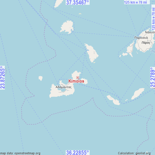
Kímolos GPS coordinates[2]
36° 47' 37.248" North, 24° 34' 32.772" East
| Map corner | latitude | longitude |
|---|---|---|
| Upper-left | 37.35467°, | 23.87265° |
| Center: | 36.79368°, | 24.57577° |
| Lower-right: | 36.22855°, | 25.2789° |
| Map W x H: | 125.2×125.2 km | = 77.8×77.8mi |
| max Lat: | 41.72048° ⇑91.4% North |
| Kímolos: | 36.79368° |
| min Lat: | ⇓8.6% South 34.8346° |
| min Long | Kímolos | max Long |
| 19.40494° | 24.57577° | 29.59361° |
| W 84%⇐ | ⇒16% E |
Elevation
Elevation of Kímolos is 81 m = 266 ft, and this is 87.9 m = 288 ft below average elevation for this country.
| Max E: |
1439 m = 4721 ft | 50.1% |
| Avg. | 168.9 m = 554 ft | |
| Kímolos | 81 m = 266 ft | |
Min E: |
0 m = 0 ft | 49.9% |
See also: Greece elevation on elevation.city.
Geographical zone
Kímolos is located in North temperate zone (between Tropic of Cancer and the Arctic Circle). Distance of this Northern Tropic circle is 1485.2 km =922.9 mi to South.| Distance of | km | miles | from Kímolos |
|---|---|---|---|
| North Pole | 5916 | 3676 | to North |
| Arctic Circle | 3310.1 | 2056.8 | to North |
| Tropic Cancer | 1485.2 | 922.9 | to South |
| Equator | 4091.1 | 2542.1 | to South |


Nearby cities:
15 places around Kímolos: (largest is in red/bold)
• Adámas
13.8 km =8.6 mi,  236°
236°
• Antíparos
52.7 km =32.7 mi,  58°
58°
• Apollonía
23.9 km =14.9 mi,  33°
33°
• Artemón
24.7 km =15.3 mi, 32°
• Folégandros
35.8 km =22.2 mi,  120°
120°
• Livádion
39.5 km =24.5 mi,  352°
352°
• Mílos
14.3 km =8.9 mi,  247°
247°
• Pláka
14.7 km =9.1 mi, 247°
• Páros
60.3 km =37.5 mi, 57°
• Péran Triovasálos
13.7 km =8.5 mi, 244°
• Sérifos
40.5 km =25.2 mi, 351°
• Síkinos
49.3 km =30.6 mi,  102°
102°
• Triovasálos
13.8 km =8.6 mi, 246°
• Trypití
14.6 km =9.1 mi, 244°
• Íos
63.4 km =39.4 mi, 96°
Sources, notices
• [Note1] Compared only with cities in Greece existing in our database
• [Src1] Map data: © OpenStreetMap contributors (CC-BY-SA)
• [Src2] Other city data from geonames.org with taken over terms of usage.
• [Src3] Geographical zone / Annual Mean Temperature by Robert A. Rohde @ Wikipedia
