Isthmía geodata
Isthmía (Peloponnese) is a populated place; located in Greece in Europe/Athens (GMT+3) time zone. With population of 1,134 people, there are 884 cities with bigger population in this country. Compared to other cities in Greece, 77.4% of cities are located further ↑North; 55.1% of cities are located further ←West and 85.7% of cities have higher elevation than Isthmía. Note1
Administrative division(s):
- Level 1: Peloponnese
- Level 2: Nomós Korinthías
- Level 3: Dimos Loutraki-Agioi Theodoroi


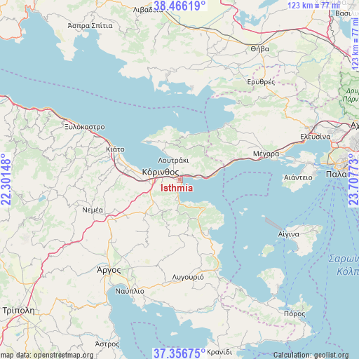
Isthmía GPS coordinates[2]
37° 54' 48.816" North, 23° 0' 16.56" East
| Map corner | latitude | longitude |
|---|---|---|
| Upper-left | 38.46619°, | 22.30148° |
| Center: | 37.91356°, | 23.0046° |
| Lower-right: | 37.35675°, | 23.70773° |
| Map W x H: | 123.4×123.4 km | = 76.7×76.7mi |
| max Lat: | 41.72048° ⇑77.4% North |
| Isthmía: | 37.91356° |
| min Lat: | ⇓22.6% South 34.8346° |
| min Long | Isthmía | max Long |
| 19.40494° | 23.0046° | 29.59361° |
| W 55.1%⇐ | ⇒44.9% E |
Elevation
Elevation of Isthmía is 12 m = 39 ft, and this is 156.9 m = 515 ft below average elevation for this country.
| Max E: |
1439 m = 4721 ft | 85.7% |
| Avg. | 168.9 m = 554 ft | |
| Isthmía | 12 m = 39 ft | |
Min E: |
0 m = 0 ft | 14.3% |
See also: Greece elevation on elevation.city.
Geographical zone
Isthmía is located in North temperate zone (between Tropic of Cancer and the Arctic Circle). Distance of this Northern Tropic circle is 1609.7 km =1000.2 mi to South.| Distance of | km | miles | from Isthmía |
|---|---|---|---|
| North Pole | 5791.5 | 3598.7 | to North |
| Arctic Circle | 3185.6 | 1979.4 | to North |
| Tropic Cancer | 1609.7 | 1000.2 | to South |
| Equator | 4215.6 | 2619.5 | to South |


Nearby cities:
15 places around Isthmía: (largest is in red/bold)
• Archaío Limáni
10 km =6.2 mi,  280°
280°
• Arkhaía Kórinthos
10.6 km =6.6 mi,  267°
267°
• Athíkia
12.6 km =7.8 mi,  211°
211°
• Examília
6.9 km =4.3 mi,  254°
254°
• Kyrás Vrýsi
1.6 km =1 mi, 267°
• Káto Almyrí
7.2 km =4.5 mi,  180°
180°
• Káto Examília
5.7 km =3.5 mi,  263°
263°
• Kórinthos
5.5 km =3.4 mi,  302°
302°
• Loutrá Oraías Elénis
5.5 km =3.4 mi,  187°
187°
• Loutráki
7.6 km =4.7 mi,  341°
341°
• Lékhaio
13.7 km =8.5 mi, 278°
• Sofikón
13.9 km =8.6 mi,  162°
162°
• Solomós
10.9 km =6.8 mi, 247°
• Xilokériza
6.5 km =4 mi,  237°
237°
• Ágioi Theódoroi
12.2 km =7.6 mi,  82°
82°
Sources, notices
• [Note1] Compared only with cities in Greece existing in our database
• [Src1] Map data: © OpenStreetMap contributors (CC-BY-SA)
• [Src2] Other city data from geonames.org with taken over terms of usage.
• [Src3] Geographical zone / Annual Mean Temperature by Robert A. Rohde @ Wikipedia
