Royítika geodata
Royítika (West Greece) is a populated place; located in Greece in Europe/Athens (GMT+3) time zone. With population of 1,288 people, there are 783 cities with bigger population in this country. Compared to other cities in Greece, 68.2% of cities are located further ↑North; 78.8% of cities are located further →East and 86.6% of cities have higher elevation than Royítika. Note1


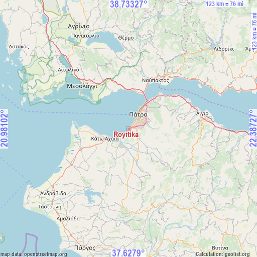
Royítika GPS coordinates[2]
38° 10' 57.648" North, 21° 41' 2.904" East
| Map corner | latitude | longitude |
|---|---|---|
| Upper-left | 38.73327°, | 20.98102° |
| Center: | 38.18268°, | 21.68414° |
| Lower-right: | 37.6279°, | 22.38727° |
| Map W x H: | 122.9×122.9 km | = 76.4×76.4mi |
| max Lat: | 41.72048° ⇑68.2% North |
| Royítika: | 38.18268° |
| min Lat: | ⇓31.8% South 34.8346° |
| min Long | Royítika | max Long |
| 19.40494° | 21.68414° | 29.59361° |
| W 21.2%⇐ | ⇒78.8% E |
Elevation
Elevation of Royítika is 11 m = 36 ft, and this is 157.9 m = 518 ft below average elevation for this country.
| Max E: |
1439 m = 4721 ft | 86.6% |
| Avg. | 168.9 m = 554 ft | |
| Royítika | 11 m = 36 ft | |
Min E: |
0 m = 0 ft | 13.4% |
See also: Greece elevation on elevation.city.
Geographical zone
Royítika is located in North temperate zone (between Tropic of Cancer and the Arctic Circle). Distance of this Northern Tropic circle is 1639.6 km =1018.8 mi to South.| Distance of | km | miles | from Royítika |
|---|---|---|---|
| North Pole | 5761.5 | 3580 | to North |
| Arctic Circle | 3155.7 | 1960.9 | to North |
| Tropic Cancer | 1639.6 | 1018.8 | to South |
| Equator | 4245.5 | 2638 | to South |


Nearby cities:
15 places around Royítika: (largest is in red/bold)
• Aktaío
16.6 km =10.3 mi,  35°
35°
• Antirrio
17.8 km =11.1 mi,  23°
23°
• Chalandrítsa
12 km =7.5 mi,  133°
133°
• Kamínia
6.5 km =4 mi,  235°
235°
• Káto Achaḯa
12.3 km =7.6 mi,  252°
252°
• Káto Mazaráki
12.8 km =8 mi,  193°
193°
• Limnokhórion
18.4 km =11.4 mi,  255°
255°
• Mindilóglion
1.5 km =0.9 mi,  84°
84°
• Monodhéndrion
1.2 km =0.7 mi,  198°
198°
• Ovriá
4 km =2.5 mi, 80°
• Paralía
2.4 km =1.5 mi, 42°
• Pátra
8.2 km =5.1 mi,  32°
32°
• Río
15.3 km =9.5 mi, 35°
• Vrachnaíika
2.7 km =1.7 mi,  213°
213°
• Áno Kastrítsi
16.6 km =10.3 mi,  53°
53°
Sources, notices
• [Note1] Compared only with cities in Greece existing in our database
• [Src1] Map data: © OpenStreetMap contributors (CC-BY-SA)
• [Src2] Other city data from geonames.org with taken over terms of usage.
• [Src3] Geographical zone / Annual Mean Temperature by Robert A. Rohde @ Wikipedia
