Galatás geodata
Galatás (West Greece) is a populated place; located in Greece in Europe/Athens (GMT+3) time zone. With population of 1,057 people, there are 957 cities with bigger population in this country. Compared to other cities in Greece, 64.6% of cities are located further ↑North; 81.8% of cities are located further →East and 87.7% of cities have higher elevation than Galatás. Note1
Administrative division(s):
- Level 1: West Greece
- Level 2: Nomós Aitolías kai Akarnanías
- Level 3: Dimos Nafpaktia


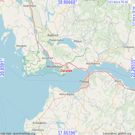
Galatás GPS coordinates[2]
38° 21' 26.712" North, 21° 33' 43.992" East
| Map corner | latitude | longitude |
|---|---|---|
| Upper-left | 38.90668°, | 20.8591° |
| Center: | 38.35742°, | 21.56222° |
| Lower-right: | 37.80396°, | 22.26535° |
| Map W x H: | 122.6×122.6 km | = 76.2×76.2mi |
| max Lat: | 41.72048° ⇑64.6% North |
| Galatás: | 38.35742° |
| min Lat: | ⇓35.4% South 34.8346° |
| min Long | Galatás | max Long |
| 19.40494° | 21.56222° | 29.59361° |
| W 18.2%⇐ | ⇒81.8% E |
Elevation
Elevation of Galatás is 10 m = 33 ft, and this is 158.9 m = 521 ft below average elevation for this country.
| Max E: |
1439 m = 4721 ft | 87.7% |
| Avg. | 168.9 m = 554 ft | |
| Galatás | 10 m = 33 ft | |
Min E: |
0 m = 0 ft | 12.3% |
See also: Greece elevation on elevation.city.
Geographical zone
Galatás is located in North temperate zone (between Tropic of Cancer and the Arctic Circle). Distance of this Northern Tropic circle is 1659 km =1030.9 mi to South.| Distance of | km | miles | from Galatás |
|---|---|---|---|
| North Pole | 5742.1 | 3568 | to North |
| Arctic Circle | 3136.2 | 1948.7 | to North |
| Tropic Cancer | 1659 | 1030.9 | to South |
| Equator | 4264.9 | 2650.1 | to South |


Nearby cities:
15 places around Galatás: (largest is in red/bold)
• Aitolikó
20.2 km =12.6 mi,  295°
295°
• Aktaío
21.1 km =13.1 mi,  106°
106°
• Antirrio
17.9 km =11.1 mi,  99°
99°
• Gavaloú
19.3 km =12 mi,  352°
352°
• Grammatikoú
19.6 km =12.2 mi, 345°
• Káto Makrinoú
15.4 km =9.6 mi,  20°
20°
• Lakkopetra
22.6 km =14 mi,  204°
204°
• Mataránga
20 km =12.4 mi,  337°
337°
• Mesolóngi
11.5 km =7.1 mi,  277°
277°
• Pappadhátai
21.3 km =13.2 mi,  332°
332°
• Paralía
21.5 km =13.4 mi,  145°
145°
• Pátra
19.6 km =12.2 mi,  129°
129°
• Royítika
22.2 km =13.8 mi, 151°
• Río
20.6 km =12.8 mi, 109°
• Áyios Andréas
18.8 km =11.7 mi,  357°
357°
Sources, notices
• [Note1] Compared only with cities in Greece existing in our database
• [Src1] Map data: © OpenStreetMap contributors (CC-BY-SA)
• [Src2] Other city data from geonames.org with taken over terms of usage.
• [Src3] Geographical zone / Annual Mean Temperature by Robert A. Rohde @ Wikipedia
