Antimácheia geodata
Antimácheia (South Aegean) is a populated place; located in Greece in Europe/Athens (GMT+3) time zone. With population of 2,251 people, there are 454 cities with bigger population in this country. Compared to other cities in Greece, 91.2% of cities are located further ↑North; 98.7% of cities are located further ←West and 66.5% of cities have lower elevation than Antimácheia. Note1


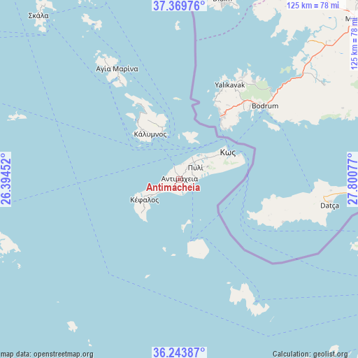
Antimácheia GPS coordinates[2]
36° 48' 31.968" North, 27° 5' 51.504" East
| Map corner | latitude | longitude |
|---|---|---|
| Upper-left | 37.36976°, | 26.39452° |
| Center: | 36.80888°, | 27.09764° |
| Lower-right: | 36.24387°, | 27.80077° |
| Map W x H: | 125.2×125.2 km | = 77.8×77.8mi |
| max Lat: | 41.72048° ⇑91.2% North |
| Antimácheia: | 36.80888° |
| min Lat: | ⇓8.8% South 34.8346° |
| min Long | Antimácheia | max Long |
| 19.40494° | 27.09764° | 29.59361° |
| W 98.7%⇐ | ⇒1.3% E |
Elevation
Elevation of Antimácheia is 145 m = 476 ft, and this is 23.9 m = 78 ft below average elevation for this country.
| Max E: |
1439 m = 4721 ft | 33.5% |
| Avg. | 168.9 m = 554 ft | |
| Antimácheia | 145 m = 476 ft | |
Min E: |
0 m = 0 ft | 66.5% |
See also: Greece elevation on elevation.city.
Geographical zone
Antimácheia is located in North temperate zone (between Tropic of Cancer and the Arctic Circle). Distance of this Northern Tropic circle is 1486.8 km =923.9 mi to South.| Distance of | km | miles | from Antimácheia |
|---|---|---|---|
| North Pole | 5914.3 | 3675 | to North |
| Arctic Circle | 3308.4 | 2055.7 | to North |
| Tropic Cancer | 1486.8 | 923.9 | to South |
| Equator | 4092.8 | 2543.1 | to South |


Nearby cities:
15 places around Antimácheia: (largest is in red/bold)
• Agía Marína
44.2 km =27.5 mi,  330°
330°
• Kamara
46 km =28.6 mi, 328°
• Kardámaina
4.9 km =3 mi,  125°
125°
• Kos
19.3 km =12 mi,  61°
61°
• Kálymnos
18.7 km =11.6 mi, 327°
• Kéfalos
14.2 km =8.8 mi,  240°
240°
• Lakkí
42.2 km =26.2 mi, 328°
• Leipsoí
60.4 km =37.5 mi, 330°
• Linopótis
10.4 km =6.5 mi,  47°
47°
• Mandráki
22.2 km =13.8 mi,  171°
171°
• Megálo Chorió
45.1 km =28 mi,  150°
150°
• Pylí
6.8 km =4.2 mi, 54°
• Pánormos
23 km =14.3 mi,  321°
321°
• Xirókampos
39.4 km =24.5 mi, 328°
• Zipári
12.2 km =7.6 mi, 51°
Sources, notices
• [Note1] Compared only with cities in Greece existing in our database
• [Src1] Map data: © OpenStreetMap contributors (CC-BY-SA)
• [Src2] Other city data from geonames.org with taken over terms of usage.
• [Src3] Geographical zone / Annual Mean Temperature by Robert A. Rohde @ Wikipedia
