Mandráki geodata
Mandráki (South Aegean) is a seat of a third-order administrative division; located in Greece in Europe/Athens (GMT+3) time zone. With population of 682 people, there are 1438 cities with bigger population in this country. Compared to other cities in Greece, 92.4% of cities are located further ↑North; 98.8% of cities are located further ←West and 92.5% of cities have higher elevation than Mandráki. Note1


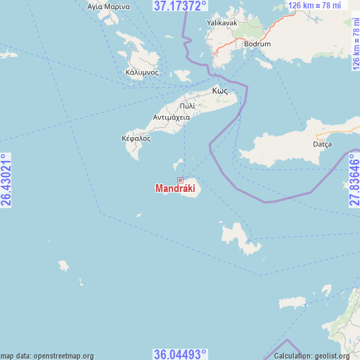
Mandráki GPS coordinates[2]
36° 36' 41.004" North, 27° 7' 59.988" East
| Map corner | latitude | longitude |
|---|---|---|
| Upper-left | 37.17372°, | 26.43021° |
| Center: | 36.61139°, | 27.13333° |
| Lower-right: | 36.04493°, | 27.83646° |
| Map W x H: | 125.5×125.5 km | = 78×78mi |
| max Lat: | 41.72048° ⇑92.4% North |
| Mandráki: | 36.61139° |
| min Lat: | ⇓7.6% South 34.8346° |
| min Long | Mandráki | max Long |
| 19.40494° | 27.13333° | 29.59361° |
| W 98.8%⇐ | ⇒1.2% E |
Elevation
Elevation of Mandráki is 7 m = 23 ft, and this is 161.9 m = 531 ft below average elevation for this country.
| Max E: |
1439 m = 4721 ft | 92.5% |
| Avg. | 168.9 m = 554 ft | |
| Mandráki | 7 m = 23 ft | |
Min E: |
0 m = 0 ft | 7.5% |
See also: Greece elevation on elevation.city.
Geographical zone
Mandráki is located in North temperate zone (between Tropic of Cancer and the Arctic Circle). Distance of this Northern Tropic circle is 1464.9 km =910.2 mi to South.| Distance of | km | miles | from Mandráki |
|---|---|---|---|
| North Pole | 5936.3 | 3688.6 | to North |
| Arctic Circle | 3330.4 | 2069.4 | to North |
| Tropic Cancer | 1464.9 | 910.2 | to South |
| Equator | 4070.8 | 2529.5 | to South |


Nearby cities:
15 places around Mandráki: (largest is in red/bold)
• Agía Marína
65.4 km =40.6 mi,  337°
337°
• Antimácheia
22.2 km =13.8 mi,  351°
351°
• Chálki
60.9 km =37.8 mi,  135°
135°
• Kardámaina
19.1 km =11.9 mi,  2°
2°
• Kos
34.2 km =21.3 mi,  23°
23°
• Kálymnos
40 km =24.9 mi, 340°
• Kéfalos
21.5 km =13.4 mi,  313°
313°
• Lakkí
63.2 km =39.3 mi, 336°
• Linopótis
29.3 km =18.2 mi,  8°
8°
• Megálo Chorió
25.7 km =16 mi,  132°
132°
• Pylí
26 km =16.2 mi, 5°
• Pánormos
43.7 km =27.2 mi, 336°
• Sými
62.7 km =39 mi,  89°
89°
• Xirókampos
60.4 km =37.5 mi, 336°
• Zipári
30.2 km =18.8 mi, 12°
Sources, notices
• [Note1] Compared only with cities in Greece existing in our database
• [Src1] Map data: © OpenStreetMap contributors (CC-BY-SA)
• [Src2] Other city data from geonames.org with taken over terms of usage.
• [Src3] Geographical zone / Annual Mean Temperature by Robert A. Rohde @ Wikipedia
