Kos geodata
Kos (South Aegean) is a seat of a third-order administrative division; located in Greece in Europe/Athens (GMT+3) time zone. With population of 19,244 people, there are 94 cities with bigger population in this country. Compared to other cities in Greece, 90.5% of cities are located further ↑North; 99.1% of cities are located further ←West and 99.6% of cities have higher elevation than Kos. Note1


Kos GPS coordinates[2]
36° 53' 34.62" North, 27° 17' 15.648" East
| Map corner | latitude | longitude |
|---|---|---|
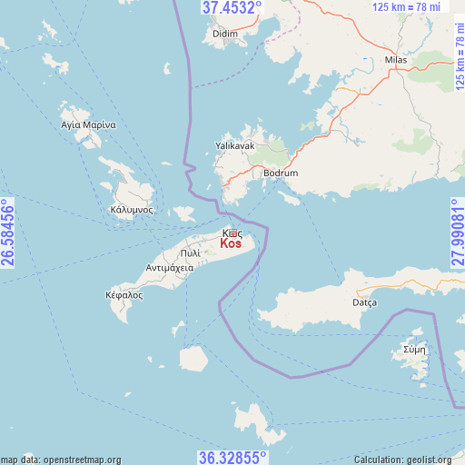
| Upper-left | 37.4532°, | 26.58456° |
| Center: | 36.89295°, | 27.28768° |
| Lower-right: | 36.32855°, | 27.99081° |
| Map W x H: | 125×125 km | = 77.7×77.7mi |
| max Lat: | 41.72048° ⇑90.5% North |
| Kos: | 36.89295° |
| min Lat: | ⇓9.5% South 34.8346° |
| min Long | Kos | max Long |
| 19.40494° | 27.28768° | 29.59361° |
| W 99.1%⇐ | ⇒0.90000000000001% E |
Elevation
Elevation of Kos is 1 m = 3 ft, and this is 167.9 m = 551 ft below average elevation for this country.
| Max E: |
1439 m = 4721 ft | 99.6% |
| Avg. | 168.9 m = 554 ft | |
| Kos | 1 m = 3 ft | |
Min E: |
0 m = 0 ft | 0.4% |
See also: Greece elevation on elevation.city.
Geographical zone
Kos is located in North temperate zone (between Tropic of Cancer and the Arctic Circle). Distance of this Northern Tropic circle is 1496.2 km =929.7 mi to South.| Distance of | km | miles | from Kos |
|---|---|---|---|
| North Pole | 5905 | 3669.2 | to North |
| Arctic Circle | 3299.1 | 2050 | to North |
| Tropic Cancer | 1496.2 | 929.7 | to South |
| Equator | 4102.1 | 2548.9 | to South |


Nearby cities:
15 places around Kos: (largest is in red/bold)
• Agía Marína
48.4 km =30.1 mi,  306°
306°
• Antimácheia
19.3 km =12 mi,  241°
241°
• Kamara
50.7 km =31.5 mi, 305°
• Kardámaina
17.8 km =11.1 mi,  226°
226°
• Kálymnos
27.7 km =17.2 mi,  283°
283°
• Kéfalos
33.5 km =20.8 mi, 240°
• Lakkí
47 km =29.2 mi,  304°
304°
• Linopótis
9.5 km =5.9 mi,  255°
255°
• Mandráki
34.2 km =21.3 mi,  203°
203°
• Megálo Chorió
49 km =30.4 mi,  173°
173°
• Pylí
12.6 km =7.8 mi, 244°
• Pánormos
32.3 km =20.1 mi,  285°
285°
• Sými
57.8 km =35.9 mi,  122°
122°
• Xirókampos
44.5 km =27.7 mi, 302°
• Zipári
7.5 km =4.7 mi, 256°
Sources, notices
• [Note1] Compared only with cities in Greece existing in our database
• [Src1] Map data: © OpenStreetMap contributors (CC-BY-SA)
• [Src2] Other city data from geonames.org with taken over terms of usage.
• [Src3] Geographical zone / Annual Mean Temperature by Robert A. Rohde @ Wikipedia
