Amaliapolis geodata
Amaliapolis (Thessaly) is a populated place; located in Greece in Europe/Athens (GMT+3) time zone. With population of 879 people, there are 1159 cities with bigger population in this country. Compared to other cities in Greece, 51% of cities are located further ↑North; 51.2% of cities are located further ←West and 78.7% of cities have higher elevation than Amaliapolis. Note1


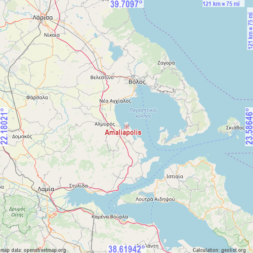
Amaliapolis GPS coordinates[2]
39° 10' 0.012" North, 22° 52' 59.988" East
| Map corner | latitude | longitude |
|---|---|---|
| Upper-left | 39.7097°, | 22.18021° |
| Center: | 39.16667°, | 22.88333° |
| Lower-right: | 38.61942°, | 23.58646° |
| Map W x H: | 121.2×121.2 km | = 75.3×75.3mi |
| max Lat: | 41.72048° ⇑51% North |
| Amaliapolis: | 39.16667° |
| min Lat: | ⇓49% South 34.8346° |
| min Long | Amaliapolis | max Long |
| 19.40494° | 22.88333° | 29.59361° |
| W 51.2%⇐ | ⇒48.8% E |
Elevation
Elevation of Amaliapolis is 19 m = 62 ft, and this is 149.9 m = 492 ft below average elevation for this country.
| Max E: |
1439 m = 4721 ft | 78.7% |
| Avg. | 168.9 m = 554 ft | |
| Amaliapolis | 19 m = 62 ft | |
Min E: |
0 m = 0 ft | 21.3% |
See also: Greece elevation on elevation.city.
Geographical zone
Amaliapolis is located in North temperate zone (between Tropic of Cancer and the Arctic Circle). Distance of this Northern Tropic circle is 1749 km =1086.8 mi to South.| Distance of | km | miles | from Amaliapolis |
|---|---|---|---|
| North Pole | 5652.1 | 3512.1 | to North |
| Arctic Circle | 3046.2 | 1892.8 | to North |
| Tropic Cancer | 1749 | 1086.8 | to South |
| Equator | 4354.9 | 2706 | to South |


Nearby cities:
15 places around Amaliapolis: (largest is in red/bold)
• Agriá
22.3 km =13.9 mi,  29°
29°
• Akhíllio
19.1 km =11.9 mi,  159°
159°
• Almyrós
10.8 km =6.7 mi,  279°
279°
• Evxinoúpolis
12.7 km =7.9 mi, 278°
• Káto Lekhónia
22.7 km =14.1 mi,  36°
36°
• Néa Anchiálos
13.8 km =8.6 mi,  336°
336°
• Néa Ionía
23.9 km =14.9 mi,  9°
9°
• Néos Plátanos
7.7 km =4.8 mi,  266°
266°
• Pteleós
14 km =8.7 mi,  154°
154°
• Soúrpi
7.2 km =4.5 mi,  169°
169°
• Tríkeri
18.2 km =11.3 mi,  113°
113°
• Volos
22.2 km =13.8 mi, 13°
• Ágios Geórgios Ferón
24.4 km =15.2 mi, 337°
• Álli Meriá
24.2 km =15 mi,  20°
20°
• Áno Lekhónia
23.2 km =14.4 mi, 39°
Sources, notices
• [Note1] Compared only with cities in Greece existing in our database
• [Src1] Map data: © OpenStreetMap contributors (CC-BY-SA)
• [Src2] Other city data from geonames.org with taken over terms of usage.
• [Src3] Geographical zone / Annual Mean Temperature by Robert A. Rohde @ Wikipedia
