Soúrpi geodata
Soúrpi (Thessaly) is a populated place; located in Greece in Europe/Athens (GMT+3) time zone. With population of 1,457 people, there are 689 cities with bigger population in this country. Compared to other cities in Greece, 52.8% of cities are located further ↑North; 51.7% of cities are located further ←West and 65.5% of cities have higher elevation than Soúrpi. Note1


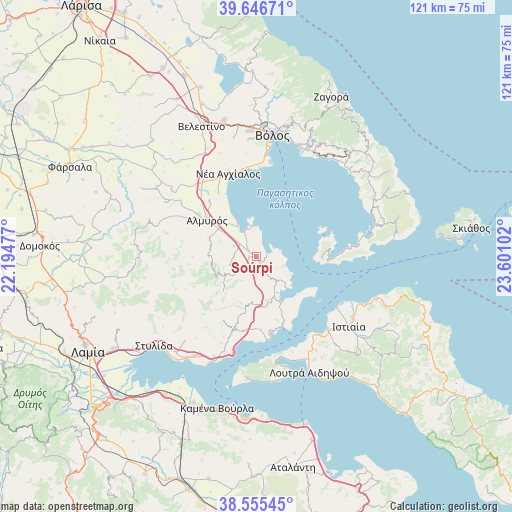
Soúrpi GPS coordinates[2]
39° 6' 11.484" North, 22° 53' 52.404" East
| Map corner | latitude | longitude |
|---|---|---|
| Upper-left | 39.64671°, | 22.19477° |
| Center: | 39.10319°, | 22.89789° |
| Lower-right: | 38.55545°, | 23.60102° |
| Map W x H: | 121.3×121.3 km | = 75.4×75.4mi |
| max Lat: | 41.72048° ⇑52.8% North |
| Soúrpi: | 39.10319° |
| min Lat: | ⇓47.2% South 34.8346° |
| min Long | Soúrpi | max Long |
| 19.40494° | 22.89789° | 29.59361° |
| W 51.7%⇐ | ⇒48.3% E |
Elevation
Elevation of Soúrpi is 38 m = 125 ft, and this is 130.9 m = 429 ft below average elevation for this country.
| Max E: |
1439 m = 4721 ft | 65.5% |
| Avg. | 168.9 m = 554 ft | |
| Soúrpi | 38 m = 125 ft | |
Min E: |
0 m = 0 ft | 34.5% |
See also: Greece elevation on elevation.city.
Geographical zone
Soúrpi is located in North temperate zone (between Tropic of Cancer and the Arctic Circle). Distance of this Northern Tropic circle is 1741.9 km =1082.4 mi to South.| Distance of | km | miles | from Soúrpi |
|---|---|---|---|
| North Pole | 5659.2 | 3516.5 | to North |
| Arctic Circle | 3053.3 | 1897.2 | to North |
| Tropic Cancer | 1741.9 | 1082.4 | to South |
| Equator | 4347.9 | 2701.7 | to South |


Nearby cities:
15 places around Soúrpi: (largest is in red/bold)
• Akhíllio
12.2 km =7.6 mi,  153°
153°
• Almyrós
14.8 km =9.2 mi,  306°
306°
• Amaliapolis
7.2 km =4.5 mi,  349°
349°
• Evxinoúpolis
16.4 km =10.2 mi,  303°
303°
• Glífa
17.7 km =11 mi,  160°
160°
• Néa Anchiálos
20.8 km =12.9 mi,  340°
340°
• Néos Plátanos
11.1 km =6.9 mi, 306°
• Néos Pírgos
24 km =14.9 mi,  140°
140°
• Oreoí
23.9 km =14.9 mi, 135°
• Paralía Rachón
26.7 km =16.6 mi,  202°
202°
• Pelasgía
18 km =11.2 mi, 196°
• Pteleós
7.3 km =4.5 mi, 139°
• Rákhai
25.7 km =16 mi, 203°
• Tríkeri
15.4 km =9.6 mi,  90°
90°
• Áyios
26.2 km =16.3 mi, 147°
Sources, notices
• [Note1] Compared only with cities in Greece existing in our database
• [Src1] Map data: © OpenStreetMap contributors (CC-BY-SA)
• [Src2] Other city data from geonames.org with taken over terms of usage.
• [Src3] Geographical zone / Annual Mean Temperature by Robert A. Rohde @ Wikipedia
