Pteleós geodata
Pteleós (Thessaly) is a populated place; located in Greece in Europe/Athens (GMT+3) time zone. With population of 1,140 people, there are 876 cities with bigger population in this country. Compared to other cities in Greece, 53.9% of cities are located further ↑North; 53.4% of cities are located further ←West and 55.2% of cities have lower elevation than Pteleós. Note1


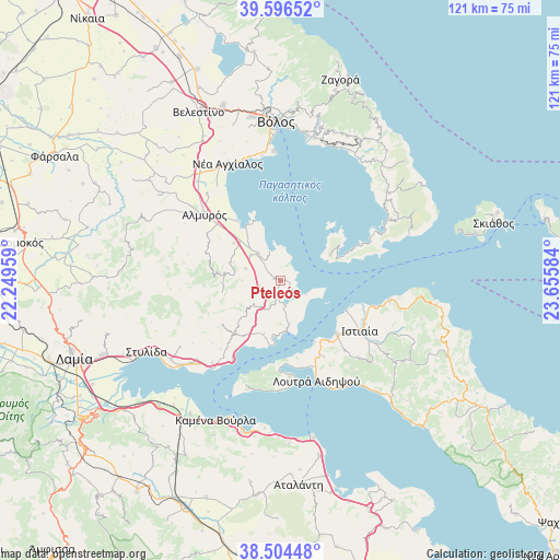
Pteleós GPS coordinates[2]
39° 3' 9.396" North, 22° 57' 9.756" East
| Map corner | latitude | longitude |
|---|---|---|
| Upper-left | 39.59652°, | 22.24959° |
| Center: | 39.05261°, | 22.95271° |
| Lower-right: | 38.50448°, | 23.65584° |
| Map W x H: | 121.4×121.4 km | = 75.4×75.4mi |
| max Lat: | 41.72048° ⇑53.9% North |
| Pteleós: | 39.05261° |
| min Lat: | ⇓46.1% South 34.8346° |
| min Long | Pteleós | max Long |
| 19.40494° | 22.95271° | 29.59361° |
| W 53.4%⇐ | ⇒46.6% E |
Elevation
Elevation of Pteleós is 99 m = 325 ft, and this is 69.9 m = 229 ft below average elevation for this country.
| Max E: |
1439 m = 4721 ft | 44.8% |
| Avg. | 168.9 m = 554 ft | |
| Pteleós | 99 m = 325 ft | |
Min E: |
0 m = 0 ft | 55.2% |
See also: Greece elevation on elevation.city.
Geographical zone
Pteleós is located in North temperate zone (between Tropic of Cancer and the Arctic Circle). Distance of this Northern Tropic circle is 1736.3 km =1078.9 mi to South.| Distance of | km | miles | from Pteleós |
|---|---|---|---|
| North Pole | 5664.8 | 3519.9 | to North |
| Arctic Circle | 3058.9 | 1900.7 | to North |
| Tropic Cancer | 1736.3 | 1078.9 | to South |
| Equator | 4342.2 | 2698.1 | to South |


Nearby cities:
15 places around Pteleós: (largest is in red/bold)
• Aidipsós
20.9 km =13 mi,  157°
157°
• Akhíllio
5.3 km =3.3 mi,  172°
172°
• Almyrós
22 km =13.7 mi,  310°
310°
• Amaliapolis
14 km =8.7 mi,  334°
334°
• Giáltra
21.2 km =13.2 mi, 174°
• Glífa
11.1 km =6.9 mi, 173°
• Istiaía
20.4 km =12.7 mi,  122°
122°
• Loutrá Aidhipsoú
23.2 km =14.4 mi, 159°
• Néos Plátanos
18.4 km =11.4 mi, 311°
• Néos Pírgos
16.6 km =10.3 mi,  141°
141°
• Oreoí
16.6 km =10.3 mi,  133°
133°
• Pelasgía
15.2 km =9.4 mi,  220°
220°
• Soúrpi
7.3 km =4.5 mi,  319°
319°
• Tríkeri
12 km =7.5 mi,  63°
63°
• Áyios
19 km =11.8 mi,  150°
150°
Sources, notices
• [Note1] Compared only with cities in Greece existing in our database
• [Src1] Map data: © OpenStreetMap contributors (CC-BY-SA)
• [Src2] Other city data from geonames.org with taken over terms of usage.
• [Src3] Geographical zone / Annual Mean Temperature by Robert A. Rohde @ Wikipedia
