Xánthi geodata
Xánthi (East Macedonia and Thrace) is a seat of a second-order administrative division; located in Greece in Europe/Athens (GMT+3) time zone. With population of 48,221 people, there are 41 cities with bigger population in this country. Compared to other cities in Greece, 96.4% of cities are located further ↓South; 86.1% of cities are located further ←West and 50.1% of cities have higher elevation than Xánthi. Note1
Administrative division(s):
- Level 1: East Macedonia and Thrace
- Level 2: Nomós Xánthis
- Level 3: Dimos Xanthi


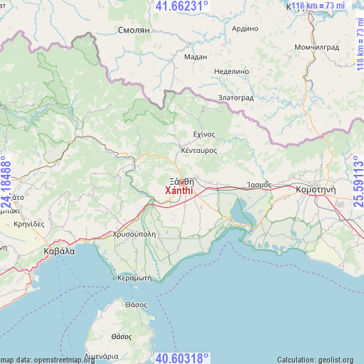
Xánthi GPS coordinates[2]
41° 8' 5.568" North, 24° 53' 16.8" East
| Map corner | latitude | longitude |
|---|---|---|
| Upper-left | 41.66231°, | 24.18488° |
| Center: | 41.13488°, | 24.888° |
| Lower-right: | 40.60318°, | 25.59113° |
| Map W x H: | 117.8×117.8 km | = 73.2×73.2mi |
| max Lat: | 41.72048° ⇑3.6% North |
| Xánthi: | 41.13488° |
| min Lat: | ⇓96.4% South 34.8346° |
| min Long | Xánthi | max Long |
| 19.40494° | 24.888° | 29.59361° |
| W 86.1%⇐ | ⇒13.9% E |
Elevation
Elevation of Xánthi is 81 m = 266 ft, and this is 87.9 m = 288 ft below average elevation for this country.
| Max E: |
1439 m = 4721 ft | 50.1% |
| Avg. | 168.9 m = 554 ft | |
| Xánthi | 81 m = 266 ft | |
Min E: |
0 m = 0 ft | 49.9% |
See also: Xánthi elevation on elevation.city.
Geographical zone
Xánthi is located in North temperate zone (between Tropic of Cancer and the Arctic Circle). Distance of this Northern Tropic circle is 1967.9 km =1222.8 mi to South.| Distance of | km | miles | from Xánthi |
|---|---|---|---|
| North Pole | 5433.3 | 3376.1 | to North |
| Arctic Circle | 2827.4 | 1756.9 | to North |
| Tropic Cancer | 1967.9 | 1222.8 | to South |
| Equator | 4573.8 | 2842 | to South |


Nearby cities:
15 places around Xánthi: (largest is in red/bold)
• Echínos
17.2 km =10.7 mi,  24°
24°
• Fília
9.7 km =6 mi,  87°
87°
• Genisséa
10.3 km =6.4 mi,  142°
142°
• Iliokentima
22.3 km =13.9 mi,  202°
202°
• Kimméria
4.5 km =2.8 mi,  71°
71°
• Lefkópetra
7.6 km =4.7 mi, 88°
• Mýki
12.4 km =7.7 mi,  12°
12°
• Peteinós
3.9 km =2.4 mi,  167°
167°
• Petrochóri
6.6 km =4.1 mi,  216°
216°
• Páchni
18.9 km =11.7 mi,  1°
1°
• Smínthi
11.1 km =6.9 mi,  350°
350°
• Sélero
8.9 km =5.5 mi, 90°
• Símantra
11.5 km =7.1 mi, 88°
• Ávato
20.4 km =12.7 mi, 200°
• Évlalo
18.4 km =11.4 mi, 203°
Sources, notices
• [Note1] Compared only with cities in Greece existing in our database
• [Src1] Map data: © OpenStreetMap contributors (CC-BY-SA)
• [Src2] Other city data from geonames.org with taken over terms of usage.
• [Src3] Geographical zone / Annual Mean Temperature by Robert A. Rohde @ Wikipedia
