Peteinós geodata
Peteinós (East Macedonia and Thrace) is a populated place; located in Greece in Europe/Athens (GMT+3) time zone. With population of 1,014 people, there are 1001 cities with bigger population in this country. Compared to other cities in Greece, 95.3% of cities are located further ↓South; 86.3% of cities are located further ←West and 62.6% of cities have higher elevation than Peteinós. Note1
Administrative division(s):
- Level 1: East Macedonia and Thrace
- Level 2: Nomós Xánthis
- Level 3: Dimos Abdera


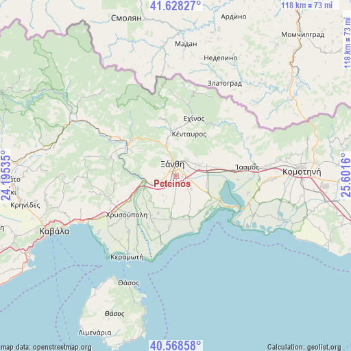
Peteinós GPS coordinates[2]
41° 6' 2.016" North, 24° 53' 54.492" East
| Map corner | latitude | longitude |
|---|---|---|
| Upper-left | 41.62827°, | 24.19535° |
| Center: | 41.10056°, | 24.89847° |
| Lower-right: | 40.56858°, | 25.6016° |
| Map W x H: | 117.8×117.8 km | = 73.2×73.2mi |
| max Lat: | 41.72048° ⇑4.7% North |
| Peteinós: | 41.10056° |
| min Lat: | ⇓95.3% South 34.8346° |
| min Long | Peteinós | max Long |
| 19.40494° | 24.89847° | 29.59361° |
| W 86.3%⇐ | ⇒13.7% E |
Elevation
Elevation of Peteinós is 44 m = 144 ft, and this is 124.9 m = 410 ft below average elevation for this country.
| Max E: |
1439 m = 4721 ft | 62.6% |
| Avg. | 168.9 m = 554 ft | |
| Peteinós | 44 m = 144 ft | |
Min E: |
0 m = 0 ft | 37.4% |
See also: Greece elevation on elevation.city.
Geographical zone
Peteinós is located in North temperate zone (between Tropic of Cancer and the Arctic Circle). Distance of this Northern Tropic circle is 1964 km =1220.4 mi to South.| Distance of | km | miles | from Peteinós |
|---|---|---|---|
| North Pole | 5437.1 | 3378.5 | to North |
| Arctic Circle | 2831.2 | 1759.2 | to North |
| Tropic Cancer | 1964 | 1220.4 | to South |
| Equator | 4570 | 2839.7 | to South |


Nearby cities:
15 places around Peteinós: (largest is in red/bold)
• Chrysoúpolis
21.4 km =13.3 mi,  233°
233°
• Echínos
20.4 km =12.7 mi,  17°
17°
• Fília
9.8 km =6.1 mi,  64°
64°
• Genisséa
6.9 km =4.3 mi,  128°
128°
• Iliokentima
19.2 km =11.9 mi,  208°
208°
• Kimméria
6.2 km =3.9 mi,  32°
32°
• Lefkópetra
7.9 km =4.9 mi, 59°
• Mýki
16 km =9.9 mi,  6°
6°
• Petrochóri
5 km =3.1 mi,  253°
253°
• Smínthi
15 km =9.3 mi,  349°
349°
• Sélero
8.8 km =5.5 mi,  65°
65°
• Símantra
11.4 km =7.1 mi, 68°
• Xánthi
3.9 km =2.4 mi, 347°
• Ávato
17.2 km =10.7 mi, 207°
• Évlalo
15.4 km =9.6 mi, 212°
Sources, notices
• [Note1] Compared only with cities in Greece existing in our database
• [Src1] Map data: © OpenStreetMap contributors (CC-BY-SA)
• [Src2] Other city data from geonames.org with taken over terms of usage.
• [Src3] Geographical zone / Annual Mean Temperature by Robert A. Rohde @ Wikipedia
