Lefkópetra geodata
Lefkópetra (East Macedonia and Thrace) is a populated place; located in Greece in Europe/Athens (GMT+3) time zone. With population of 700 people, there are 1410 cities with bigger population in this country. Compared to other cities in Greece, 96.4% of cities are located further ↓South; 87% of cities are located further ←West and 55.7% of cities have higher elevation than Lefkópetra. Note1
Administrative division(s):
- Level 1: East Macedonia and Thrace
- Level 2: Nomós Xánthis
- Level 3: Dimos Abdera


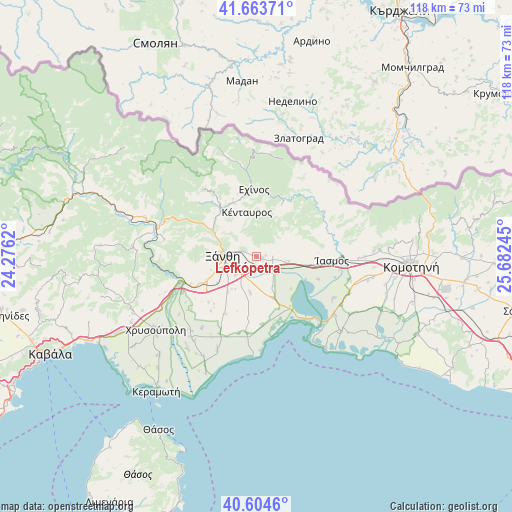
Lefkópetra GPS coordinates[2]
41° 8' 10.644" North, 24° 58' 45.552" East
| Map corner | latitude | longitude |
|---|---|---|
| Upper-left | 41.66371°, | 24.2762° |
| Center: | 41.13629°, | 24.97932° |
| Lower-right: | 40.6046°, | 25.68245° |
| Map W x H: | 117.8×117.8 km | = 73.2×73.2mi |
| max Lat: | 41.72048° ⇑3.6% North |
| Lefkópetra: | 41.13629° |
| min Lat: | ⇓96.4% South 34.8346° |
| min Long | Lefkópetra | max Long |
| 19.40494° | 24.97932° | 29.59361° |
| W 87%⇐ | ⇒13% E |
Elevation
Elevation of Lefkópetra is 64 m = 210 ft, and this is 104.9 m = 344 ft below average elevation for this country.
| Max E: |
1439 m = 4721 ft | 55.7% |
| Avg. | 168.9 m = 554 ft | |
| Lefkópetra | 64 m = 210 ft | |
Min E: |
0 m = 0 ft | 44.3% |
See also: Greece elevation on elevation.city.
Geographical zone
Lefkópetra is located in North temperate zone (between Tropic of Cancer and the Arctic Circle). Distance of this Northern Tropic circle is 1968 km =1222.9 mi to South.| Distance of | km | miles | from Lefkópetra |
|---|---|---|---|
| North Pole | 5433.1 | 3376 | to North |
| Arctic Circle | 2827.2 | 1756.7 | to North |
| Tropic Cancer | 1968 | 1222.9 | to South |
| Equator | 4573.9 | 2842.1 | to South |


Nearby cities:
15 places around Lefkópetra: (largest is in red/bold)
• Echínos
15.5 km =9.6 mi,  357°
357°
• Fília
2.1 km =1.3 mi,  81°
81°
• Genisséa
8.4 km =5.2 mi,  189°
189°
• Kimméria
3.6 km =2.2 mi,  290°
290°
• Mýki
12.9 km =8 mi,  337°
337°
• Peteinós
7.9 km =4.9 mi,  239°
239°
• Petrochóri
12.8 km =8 mi, 244°
• Páchni
20.1 km =12.5 mi, 339°
• Smínthi
14.3 km =8.9 mi,  318°
318°
• Sélero
1.3 km =0.8 mi,  102°
102°
• Símantra
3.9 km =2.4 mi,  87°
87°
• Xánthi
7.6 km =4.7 mi,  268°
268°
• Ávato
24.2 km =15 mi,  217°
217°
• Évlalo
22.7 km =14.1 mi, 221°
• Íasmos
17.3 km =10.7 mi, 93°
Sources, notices
• [Note1] Compared only with cities in Greece existing in our database
• [Src1] Map data: © OpenStreetMap contributors (CC-BY-SA)
• [Src2] Other city data from geonames.org with taken over terms of usage.
• [Src3] Geographical zone / Annual Mean Temperature by Robert A. Rohde @ Wikipedia
