Vrontoú geodata
Vrontoú (Central Macedonia) is a populated place; located in Greece in Europe/Athens (GMT+3) time zone. With population of 2,196 people, there are 468 cities with bigger population in this country. Compared to other cities in Greece, 68.3% of cities are located further ↓South; 61.8% of cities are located further →East and 61.1% of cities have lower elevation than Vrontoú. Note1
Administrative division(s):
- Level 1: Central Macedonia
- Level 2: Nomós Pierías
- Level 3: Dimos Dio-Olympos


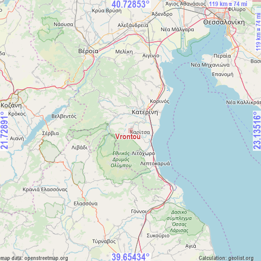
Vrontoú GPS coordinates[2]
40° 11' 36.816" North, 22° 25' 55.308" East
| Map corner | latitude | longitude |
|---|---|---|
| Upper-left | 40.72853°, | 21.72891° |
| Center: | 40.19356°, | 22.43203° |
| Lower-right: | 39.65434°, | 23.13516° |
| Map W x H: | 119.4×119.4 km | = 74.2×74.2mi |
| max Lat: | 41.72048° ⇑31.7% North |
| Vrontoú: | 40.19356° |
| min Lat: | ⇓68.3% South 34.8346° |
| min Long | Vrontoú | max Long |
| 19.40494° | 22.43203° | 29.59361° |
| W 38.2%⇐ | ⇒61.8% E |
Elevation
Elevation of Vrontoú is 122 m = 400 ft, and this is 46.9 m = 154 ft below average elevation for this country.
| Max E: |
1439 m = 4721 ft | 38.9% |
| Avg. | 168.9 m = 554 ft | |
| Vrontoú | 122 m = 400 ft | |
Min E: |
0 m = 0 ft | 61.1% |
See also: Greece elevation on elevation.city.
Geographical zone
Vrontoú is located in North temperate zone (between Tropic of Cancer and the Arctic Circle). Distance of this Northern Tropic circle is 1863.2 km =1157.7 mi to South.| Distance of | km | miles | from Vrontoú |
|---|---|---|---|
| North Pole | 5538 | 3441.2 | to North |
| Arctic Circle | 2932.1 | 1821.9 | to North |
| Tropic Cancer | 1863.2 | 1157.7 | to South |
| Equator | 4469.1 | 2777 | to South |


Nearby cities:
15 places around Vrontoú: (largest is in red/bold)
• Andromáchi
9.8 km =6.1 mi,  25°
25°
• Díon
5.1 km =3.2 mi,  118°
118°
• Ganóchora
13.9 km =8.6 mi,  22°
22°
• Karítsa
4.3 km =2.7 mi,  99°
99°
• Kateríni
10.5 km =6.5 mi,  36°
36°
• Kontariótissa
4.5 km =2.8 mi, 33°
• Káto Miliá
10.1 km =6.3 mi,  311°
311°
• Litóchoro
11.8 km =7.3 mi,  151°
151°
• Lófos
7.1 km =4.4 mi,  321°
321°
• Néa Éfesos
6.9 km =4.3 mi,  54°
54°
• Palaió Keramídi
13.7 km =8.5 mi,  11°
11°
• Perístasi
12.9 km =8 mi, 45°
• Svorónos
8.7 km =5.4 mi, 17°
• Ágios Spyrídon
1.8 km =1.1 mi, 30°
• Áno Ágios Ioánnis
15 km =9.3 mi, 20°
Sources, notices
• [Note1] Compared only with cities in Greece existing in our database
• [Src1] Map data: © OpenStreetMap contributors (CC-BY-SA)
• [Src2] Other city data from geonames.org with taken over terms of usage.
• [Src3] Geographical zone / Annual Mean Temperature by Robert A. Rohde @ Wikipedia
