Andromáchi geodata
Andromáchi (Central Macedonia) is a populated place; located in Greece in Europe/Athens (GMT+3) time zone. With population of 833 people, there are 1225 cities with bigger population in this country. Compared to other cities in Greece, 69.7% of cities are located further ↓South; 60.6% of cities are located further →East and 62.1% of cities have higher elevation than Andromáchi. Note1
Administrative division(s):
- Level 1: Central Macedonia
- Level 2: Nomós Pierías
- Level 3: Dimos Katerini


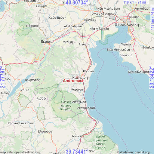
Andromáchi GPS coordinates[2]
40° 16' 22.8" North, 22° 28' 51.924" East
| Map corner | latitude | longitude |
|---|---|---|
| Upper-left | 40.80734°, | 21.77797° |
| Center: | 40.273°, | 22.48109° |
| Lower-right: | 39.73441°, | 23.18422° |
| Map W x H: | 119.3×119.3 km | = 74.1×74.1mi |
| max Lat: | 41.72048° ⇑30.3% North |
| Andromáchi: | 40.273° |
| min Lat: | ⇓69.7% South 34.8346° |
| min Long | Andromáchi | max Long |
| 19.40494° | 22.48109° | 29.59361° |
| W 39.4%⇐ | ⇒60.6% E |
Elevation
Elevation of Andromáchi is 45 m = 148 ft, and this is 123.9 m = 406 ft below average elevation for this country.
| Max E: |
1439 m = 4721 ft | 62.1% |
| Avg. | 168.9 m = 554 ft | |
| Andromáchi | 45 m = 148 ft | |
Min E: |
0 m = 0 ft | 37.9% |
See also: Greece elevation on elevation.city.
Geographical zone
Andromáchi is located in North temperate zone (between Tropic of Cancer and the Arctic Circle). Distance of this Northern Tropic circle is 1872 km =1163.2 mi to South.| Distance of | km | miles | from Andromáchi |
|---|---|---|---|
| North Pole | 5529.1 | 3435.6 | to North |
| Arctic Circle | 2923.2 | 1816.4 | to North |
| Tropic Cancer | 1872 | 1163.2 | to South |
| Equator | 4477.9 | 2782.4 | to South |


Nearby cities:
15 places around Andromáchi: (largest is in red/bold)
• Ganóchora
4.2 km =2.6 mi,  17°
17°
• Kallithéa
8.2 km =5.1 mi,  89°
89°
• Karítsa
9.5 km =5.9 mi,  179°
179°
• Kateríni
2.2 km =1.4 mi,  100°
100°
• Kontariótissa
5.3 km =3.3 mi,  198°
198°
• Káto Ágios Ioánnis
7.1 km =4.4 mi,  32°
32°
• Lófos
9.1 km =5.7 mi,  249°
249°
• Néa Trapezoúnta
7.7 km =4.8 mi, 28°
• Néa Éfesos
5.1 km =3.2 mi,  163°
163°
• Palaió Keramídi
4.8 km =3 mi,  342°
342°
• Paralía
9.8 km =6.1 mi, 93°
• Perístasi
5.1 km =3.2 mi, 88°
• Svorónos
1.6 km =1 mi, 249°
• Ágios Spyrídon
7.9 km =4.9 mi, 203°
• Áno Ágios Ioánnis
5.3 km =3.3 mi,  11°
11°
Sources, notices
• [Note1] Compared only with cities in Greece existing in our database
• [Src1] Map data: © OpenStreetMap contributors (CC-BY-SA)
• [Src2] Other city data from geonames.org with taken over terms of usage.
• [Src3] Geographical zone / Annual Mean Temperature by Robert A. Rohde @ Wikipedia
