Karítsa geodata
Karítsa (Central Macedonia) is a populated place; located in Greece in Europe/Athens (GMT+3) time zone. With population of 2,225 people, there are 461 cities with bigger population in this country. Compared to other cities in Greece, 68.2% of cities are located further ↓South; 60.6% of cities are located further →East and 77.6% of cities have higher elevation than Karítsa. Note1
Administrative division(s):
- Level 1: Central Macedonia
- Level 2: Nomós Pierías
- Level 3: Dimos Dio-Olympos


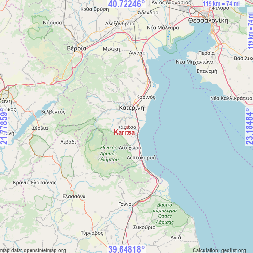
Karítsa GPS coordinates[2]
40° 11' 14.82" North, 22° 28' 54.156" East
| Map corner | latitude | longitude |
|---|---|---|
| Upper-left | 40.72246°, | 21.77859° |
| Center: | 40.18745°, | 22.48171° |
| Lower-right: | 39.64818°, | 23.18484° |
| Map W x H: | 119.4×119.4 km | = 74.2×74.2mi |
| max Lat: | 41.72048° ⇑31.8% North |
| Karítsa: | 40.18745° |
| min Lat: | ⇓68.2% South 34.8346° |
| min Long | Karítsa | max Long |
| 19.40494° | 22.48171° | 29.59361° |
| W 39.4%⇐ | ⇒60.6% E |
Elevation
Elevation of Karítsa is 20 m = 66 ft, and this is 148.9 m = 489 ft below average elevation for this country.
| Max E: |
1439 m = 4721 ft | 77.6% |
| Avg. | 168.9 m = 554 ft | |
| Karítsa | 20 m = 66 ft | |
Min E: |
0 m = 0 ft | 22.4% |
See also: Greece elevation on elevation.city.
Geographical zone
Karítsa is located in North temperate zone (between Tropic of Cancer and the Arctic Circle). Distance of this Northern Tropic circle is 1862.5 km =1157.3 mi to South.| Distance of | km | miles | from Karítsa |
|---|---|---|---|
| North Pole | 5538.6 | 3441.5 | to North |
| Arctic Circle | 2932.7 | 1822.3 | to North |
| Tropic Cancer | 1862.5 | 1157.3 | to South |
| Equator | 4468.4 | 2776.5 | to South |


Nearby cities:
15 places around Karítsa: (largest is in red/bold)
• Andromáchi
9.5 km =5.9 mi,  359°
359°
• Díon
1.8 km =1.1 mi,  171°
171°
• Ganóchora
13.6 km =8.5 mi,  5°
5°
• Kallithéa
12.6 km =7.8 mi,  40°
40°
• Kateríni
9.4 km =5.8 mi, 12°
• Kontariótissa
4.8 km =3 mi,  338°
338°
• Káto Miliá
13.9 km =8.6 mi,  302°
302°
• Litóchoro
9.8 km =6.1 mi, 171°
• Lófos
10.7 km =6.6 mi,  306°
306°
• Néa Éfesos
4.8 km =3 mi,  16°
16°
• Paralía
13.1 km =8.1 mi,  47°
47°
• Perístasi
10.9 km =6.8 mi,  27°
27°
• Svorónos
9.1 km =5.7 mi,  350°
350°
• Vrontoú
4.3 km =2.7 mi,  279°
279°
• Ágios Spyrídon
4 km =2.5 mi, 304°
Sources, notices
• [Note1] Compared only with cities in Greece existing in our database
• [Src1] Map data: © OpenStreetMap contributors (CC-BY-SA)
• [Src2] Other city data from geonames.org with taken over terms of usage.
• [Src3] Geographical zone / Annual Mean Temperature by Robert A. Rohde @ Wikipedia
