Mándalo geodata
Mándalo (Central Macedonia) is a populated place; located in Greece in Europe/Athens (GMT+3) time zone. With population of 1,204 people, there are 827 cities with bigger population in this country. Compared to other cities in Greece, 87.4% of cities are located further ↓South; 67.2% of cities are located further →East and 55.2% of cities have higher elevation than Mándalo. Note1


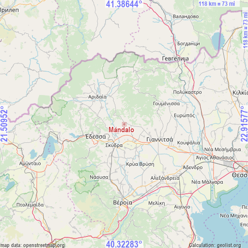
Mándalo GPS coordinates[2]
40° 51' 24.372" North, 22° 12' 45.504" East
| Map corner | latitude | longitude |
|---|---|---|
| Upper-left | 41.38644°, | 21.50952° |
| Center: | 40.85677°, | 22.21264° |
| Lower-right: | 40.32283°, | 22.91577° |
| Map W x H: | 118.3×118.3 km | = 73.5×73.5mi |
| max Lat: | 41.72048° ⇑12.6% North |
| Mándalo: | 40.85677° |
| min Lat: | ⇓87.4% South 34.8346° |
| min Long | Mándalo | max Long |
| 19.40494° | 22.21264° | 29.59361° |
| W 32.8%⇐ | ⇒67.2% E |
Elevation
Elevation of Mándalo is 65 m = 213 ft, and this is 103.9 m = 341 ft below average elevation for this country.
| Max E: |
1439 m = 4721 ft | 55.2% |
| Avg. | 168.9 m = 554 ft | |
| Mándalo | 65 m = 213 ft | |
Min E: |
0 m = 0 ft | 44.8% |
See also: Greece elevation on elevation.city.
Geographical zone
Mándalo is located in North temperate zone (between Tropic of Cancer and the Arctic Circle). Distance of this Northern Tropic circle is 1936.9 km =1203.5 mi to South.| Distance of | km | miles | from Mándalo |
|---|---|---|---|
| North Pole | 5464.2 | 3395.3 | to North |
| Arctic Circle | 2858.3 | 1776.1 | to North |
| Tropic Cancer | 1936.9 | 1203.5 | to South |
| Equator | 4542.8 | 2822.8 | to South |


Nearby cities:
15 places around Mándalo: (largest is in red/bold)
• Achladochóri
11.1 km =6.9 mi,  101°
101°
• Aravissós
7.6 km =4.7 mi, 101°
• Droseró
4.8 km =3 mi,  141°
141°
• Kallípoli
7.6 km =4.7 mi,  166°
166°
• Kalí
5.1 km =3.2 mi,  215°
215°
• Kalývia
11.3 km =7 mi,  177°
177°
• Káto Lipochóri
11.4 km =7.1 mi,  194°
194°
• Mavrovoúni
9.5 km =5.9 mi,  209°
209°
• Palaiós Mylótopos
11.3 km =7 mi,  121°
121°
• Palaífyto
9.7 km =6 mi,  147°
147°
• Profítis Ilías
6.4 km =4 mi, 221°
• Sevastianá
12.3 km =7.6 mi, 217°
• Skýdra
11.2 km =7 mi, 207°
• Theodorákeio
10.5 km =6.5 mi,  350°
350°
• Trifýlli
8.5 km =5.3 mi, 149°
Sources, notices
• [Note1] Compared only with cities in Greece existing in our database
• [Src1] Map data: © OpenStreetMap contributors (CC-BY-SA)
• [Src2] Other city data from geonames.org with taken over terms of usage.
• [Src3] Geographical zone / Annual Mean Temperature by Robert A. Rohde @ Wikipedia
