Sourotí geodata
Sourotí (Central Macedonia) is a populated place; located in Greece in Europe/Athens (GMT+3) time zone. With population of 1,048 people, there are 965 cities with bigger population in this country. Compared to other cities in Greece, 73.4% of cities are located further ↓South; 56.9% of cities are located further ←West and 56.2% of cities have lower elevation than Sourotí. Note1
Administrative division(s):
- Level 1: Central Macedonia
- Level 2: Nomós Thessaloníkis
- Level 3: Dimos Thermi


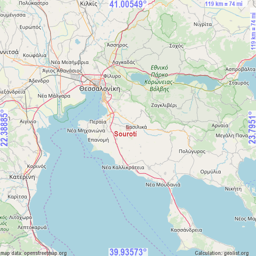
Sourotí GPS coordinates[2]
40° 28' 21.864" North, 23° 5' 31.092" East
| Map corner | latitude | longitude |
|---|---|---|
| Upper-left | 41.00549°, | 22.38885° |
| Center: | 40.47274°, | 23.09197° |
| Lower-right: | 39.93573°, | 23.7951° |
| Map W x H: | 118.9×118.9 km | = 73.9×73.9mi |
| max Lat: | 41.72048° ⇑26.6% North |
| Sourotí: | 40.47274° |
| min Lat: | ⇓73.4% South 34.8346° |
| min Long | Sourotí | max Long |
| 19.40494° | 23.09197° | 29.59361° |
| W 56.9%⇐ | ⇒43.1% E |
Elevation
Elevation of Sourotí is 102 m = 335 ft, and this is 66.9 m = 219 ft below average elevation for this country.
| Max E: |
1439 m = 4721 ft | 43.8% |
| Avg. | 168.9 m = 554 ft | |
| Sourotí | 102 m = 335 ft | |
Min E: |
0 m = 0 ft | 56.2% |
See also: Greece elevation on elevation.city.
Geographical zone
Sourotí is located in North temperate zone (between Tropic of Cancer and the Arctic Circle). Distance of this Northern Tropic circle is 1894.2 km =1177 mi to South.| Distance of | km | miles | from Sourotí |
|---|---|---|---|
| North Pole | 5506.9 | 3421.8 | to North |
| Arctic Circle | 2901 | 1802.6 | to North |
| Tropic Cancer | 1894.2 | 1177 | to South |
| Equator | 4500.1 | 2796.2 | to South |


Nearby cities:
15 places around Sourotí: (largest is in red/bold)
• Agía Paraskeví
3.8 km =2.4 mi,  284°
284°
• Chortiátis
15.2 km =9.4 mi,  2°
2°
• Epanomí
14.8 km =9.2 mi,  249°
249°
• Kardiá
8.3 km =5.2 mi,  267°
267°
• Káto Scholári
7.2 km =4.5 mi,  227°
227°
• Lákkoma
9.5 km =5.9 mi,  198°
198°
• Mesiméri
9.7 km =6 mi, 227°
• Néo Rýsi
9.2 km =5.7 mi,  286°
286°
• Panórama
13.8 km =8.6 mi,  338°
338°
• Peraía
14.3 km =8.9 mi, 281°
• Peristerá
10.5 km =6.5 mi,  36°
36°
• Plagiári
11.3 km =7 mi, 270°
• Thérmi
10.3 km =6.4 mi,  323°
323°
• Trílofos
10.2 km =6.3 mi, 267°
• Vasiliká
3.9 km =2.4 mi,  78°
78°
Sources, notices
• [Note1] Compared only with cities in Greece existing in our database
• [Src1] Map data: © OpenStreetMap contributors (CC-BY-SA)
• [Src2] Other city data from geonames.org with taken over terms of usage.
• [Src3] Geographical zone / Annual Mean Temperature by Robert A. Rohde @ Wikipedia
