Panórama geodata
Panórama (Central Macedonia) is a seat of a third-order administrative division; located in Greece in Europe/Athens (GMT+3) time zone. With population of 16,551 people, there are 102 cities with bigger population in this country. Compared to other cities in Greece, 77.1% of cities are located further ↓South; 55.6% of cities are located further ←West and 84.6% of cities have lower elevation than Panórama. Note1
Administrative division(s):
- Level 1: Central Macedonia
- Level 2: Nomós Thessaloníkis
- Level 3: Dimos Pylaia-Chortiatis


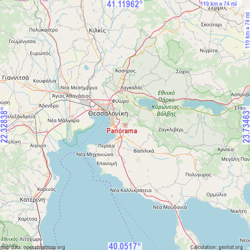
Panórama GPS coordinates[2]
40° 35' 16.044" North, 23° 1' 53.4" East
| Map corner | latitude | longitude |
|---|---|---|
| Upper-left | 41.11962°, | 22.32838° |
| Center: | 40.58779°, | 23.0315° |
| Lower-right: | 40.0517°, | 23.73463° |
| Map W x H: | 118.7×118.7 km | = 73.8×73.8mi |
| max Lat: | 41.72048° ⇑22.9% North |
| Panórama: | 40.58779° |
| min Lat: | ⇓77.1% South 34.8346° |
| min Long | Panórama | max Long |
| 19.40494° | 23.0315° | 29.59361° |
| W 55.6%⇐ | ⇒44.4% E |
Elevation
Elevation of Panórama is 368 m = 1207 ft, and this is 199.1 m = 653 ft above average elevation for this country.
| Max E: |
1439 m = 4721 ft | 15.4% |
| Panórama | 368 m 1207 ft | |
| Avg. | 168.9 m = 554 ft | |
Min E: |
0 m = 0 ft | 84.6% |
See also: Greece elevation on elevation.city.
Geographical zone
Panórama is located in North temperate zone (between Tropic of Cancer and the Arctic Circle). Distance of this Northern Tropic circle is 1907 km =1185 mi to South.| Distance of | km | miles | from Panórama |
|---|---|---|---|
| North Pole | 5494.1 | 3413.9 | to North |
| Arctic Circle | 2888.2 | 1794.6 | to North |
| Tropic Cancer | 1907 | 1185 | to South |
| Equator | 4512.9 | 2804.2 | to South |


Nearby cities:
15 places around Panórama: (largest is in red/bold)
• Ampelókipoi
11.5 km =7.1 mi,  309°
309°
• Asvestochóri
6 km =3.7 mi,  354°
354°
• Chortiátis
6.3 km =3.9 mi,  67°
67°
• Kalamariá
6.9 km =4.3 mi,  265°
265°
• Neapoli
10.5 km =6.5 mi, 313°
• Néo Rýsi
10.8 km =6.7 mi,  199°
199°
• Políchni
11.2 km =7 mi,  321°
321°
• Pylaía
4 km =2.5 mi,  288°
288°
• Péfka
8.4 km =5.2 mi,  337°
337°
• Sykiés
9.7 km =6 mi, 315°
• Thessaloníki
10.5 km =6.5 mi, 306°
• Thérmi
4.6 km =2.9 mi,  192°
192°
• Triandría
5.6 km =3.5 mi,  302°
302°
• Ágios Pávlos
8.4 km =5.2 mi, 314°
• Ágios Vasíleios
11 km =6.8 mi,  39°
39°
Sources, notices
• [Note1] Compared only with cities in Greece existing in our database
• [Src1] Map data: © OpenStreetMap contributors (CC-BY-SA)
• [Src2] Other city data from geonames.org with taken over terms of usage.
• [Src3] Geographical zone / Annual Mean Temperature by Robert A. Rohde @ Wikipedia
