Meneméni geodata
Meneméni (Central Macedonia) is a section of populated place; located in Greece in Europe/Athens (GMT+3) time zone. With population of 15,706 people, there are 108 cities with bigger population in this country. Compared to other cities in Greece, 79.8% of cities are located further ↓South; 51.7% of cities are located further ←West and 92.5% of cities have higher elevation than Meneméni. Note1
Administrative division(s):
- Level 1: Central Macedonia
- Level 2: Nomós Thessaloníkis
- Level 3: Dimos Ampelokipoi-Menemeni


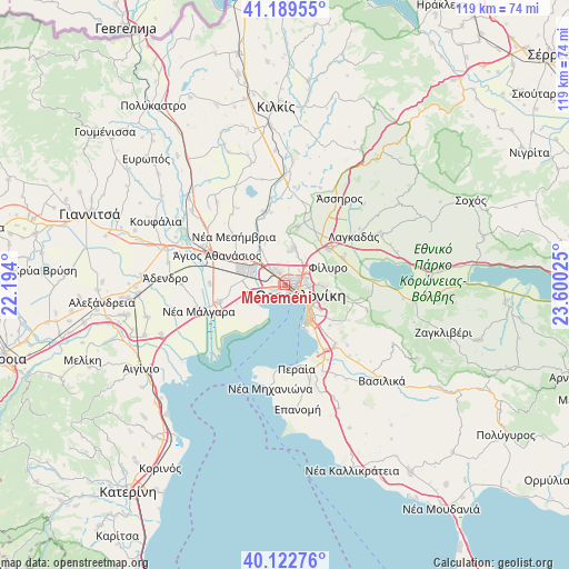
Meneméni GPS coordinates[2]
40° 39' 29.844" North, 22° 53' 49.632" East
| Map corner | latitude | longitude |
|---|---|---|
| Upper-left | 41.18955°, | 22.194° |
| Center: | 40.65829°, | 22.89712° |
| Lower-right: | 40.12276°, | 23.60025° |
| Map W x H: | 118.6×118.6 km | = 73.7×73.7mi |
| max Lat: | 41.72048° ⇑20.2% North |
| Meneméni: | 40.65829° |
| min Lat: | ⇓79.8% South 34.8346° |
| min Long | Meneméni | max Long |
| 19.40494° | 22.89712° | 29.59361° |
| W 51.7%⇐ | ⇒48.3% E |
Elevation
Elevation of Meneméni is 7 m = 23 ft, and this is 161.9 m = 531 ft below average elevation for this country.
| Max E: |
1439 m = 4721 ft | 92.5% |
| Avg. | 168.9 m = 554 ft | |
| Meneméni | 7 m = 23 ft | |
Min E: |
0 m = 0 ft | 7.5% |
See also: Greece elevation on elevation.city.
Geographical zone
Meneméni is located in North temperate zone (between Tropic of Cancer and the Arctic Circle). Distance of this Northern Tropic circle is 1914.9 km =1189.9 mi to South.| Distance of | km | miles | from Meneméni |
|---|---|---|---|
| North Pole | 5486.3 | 3409 | to North |
| Arctic Circle | 2880.4 | 1789.8 | to North |
| Tropic Cancer | 1914.9 | 1189.9 | to South |
| Equator | 4520.8 | 2809.1 | to South |


Nearby cities:
15 places around Meneméni: (largest is in red/bold)
• Ampelókipoi
2.5 km =1.6 mi,  103°
103°
• Diavatá
4.6 km =2.9 mi,  314°
314°
• Efkarpía
5.8 km =3.6 mi,  55°
55°
• Kalochóri
3.8 km =2.4 mi,  241°
241°
• Neapoli
3.8 km =2.4 mi, 98°
• Néa Magnisía
5.4 km =3.4 mi, 307°
• Oraiókastro
8.2 km =5.1 mi,  11°
11°
• Políchni
4.5 km =2.8 mi,  77°
77°
• Péfka
8.2 km =5.1 mi,  90°
90°
• Stavroúpoli
3.7 km =2.3 mi,  70°
70°
• Sykiés
4.6 km =2.9 mi, 102°
• Síndos
7.8 km =4.8 mi,  279°
279°
• Thessaloníki
3.3 km =2.1 mi,  119°
119°
• Ágios Pávlos
5.7 km =3.5 mi,  110°
110°
• Évosmos
1.7 km =1.1 mi,  34°
34°
Sources, notices
• [Note1] Compared only with cities in Greece existing in our database
• [Src1] Map data: © OpenStreetMap contributors (CC-BY-SA)
• [Src2] Other city data from geonames.org with taken over terms of usage.
• [Src3] Geographical zone / Annual Mean Temperature by Robert A. Rohde @ Wikipedia
