Évosmos geodata
Évosmos (Central Macedonia) is a seat of a third-order administrative division; located in Greece in Europe/Athens (GMT+3) time zone. In our database, there are 1823 cities with bigger population. Compared to other cities in Greece, 80.4% of cities are located further ↓South; 51.8% of cities are located further ←West and 63.2% of cities have higher elevation than Évosmos. Note1
Administrative division(s):
- Level 1: Central Macedonia
- Level 2: Nomós Thessaloníkis
- Level 3: Dimos Kordelio-Evosmos


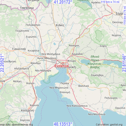
Évosmos GPS coordinates[2]
40° 40' 14.016" North, 22° 54' 29.988" East
| Map corner | latitude | longitude |
|---|---|---|
| Upper-left | 41.20172°, | 22.20521° |
| Center: | 40.67056°, | 22.90833° |
| Lower-right: | 40.13513°, | 23.61146° |
| Map W x H: | 118.6×118.6 km | = 73.7×73.7mi |
| max Lat: | 41.72048° ⇑19.6% North |
| Évosmos: | 40.67056° |
| min Lat: | ⇓80.4% South 34.8346° |
| min Long | Évosmos | max Long |
| 19.40494° | 22.90833° | 29.59361° |
| W 51.8%⇐ | ⇒48.2% E |
Elevation
Elevation of Évosmos is 43 m = 141 ft, and this is 125.9 m = 413 ft below average elevation for this country.
| Max E: |
1439 m = 4721 ft | 63.2% |
| Avg. | 168.9 m = 554 ft | |
| Évosmos | 43 m = 141 ft | |
Min E: |
0 m = 0 ft | 36.8% |
See also: Greece elevation on elevation.city.
Geographical zone
Évosmos is located in North temperate zone (between Tropic of Cancer and the Arctic Circle). Distance of this Northern Tropic circle is 1916.2 km =1190.7 mi to South.| Distance of | km | miles | from Évosmos |
|---|---|---|---|
| North Pole | 5484.9 | 3408.2 | to North |
| Arctic Circle | 2879 | 1788.9 | to North |
| Tropic Cancer | 1916.2 | 1190.7 | to South |
| Equator | 4522.1 | 2809.9 | to South |


Nearby cities:
15 places around Évosmos: (largest is in red/bold)
• Ampelókipoi
2.5 km =1.6 mi,  142°
142°
• Diavatá
4.6 km =2.9 mi,  293°
293°
• Efkarpía
4.3 km =2.7 mi,  63°
63°
• Kalochóri
5.4 km =3.4 mi,  233°
233°
• Meneméni
1.7 km =1.1 mi,  214°
214°
• Neapoli
3.4 km =2.1 mi,  124°
124°
• Neochoroúda
8 km =5 mi,  339°
339°
• Néa Magnisía
5.6 km =3.5 mi, 290°
• Oraiókastro
6.7 km =4.2 mi,  6°
6°
• Políchni
3.4 km =2.1 mi,  97°
97°
• Péfka
7.3 km =4.5 mi, 100°
• Stavroúpoli
2.5 km =1.6 mi,  92°
92°
• Sykiés
4.3 km =2.7 mi, 123°
• Thessaloníki
3.5 km =2.2 mi,  147°
147°
• Ágios Pávlos
5.5 km =3.4 mi,  127°
127°
Sources, notices
• [Note1] Compared only with cities in Greece existing in our database
• [Src1] Map data: © OpenStreetMap contributors (CC-BY-SA)
• [Src2] Other city data from geonames.org with taken over terms of usage.
• [Src3] Geographical zone / Annual Mean Temperature by Robert A. Rohde @ Wikipedia
