Diavatá geodata
Diavatá (Central Macedonia) is a populated place; located in Greece in Europe/Athens (GMT+3) time zone. With population of 10,216 people, there are 139 cities with bigger population in this country. Compared to other cities in Greece, 80.8% of cities are located further ↓South; 50.3% of cities are located further ←West and 82.6% of cities have higher elevation than Diavatá. Note1
Administrative division(s):
- Level 1: Central Macedonia
- Level 2: Nomós Thessaloníkis
- Level 3: Dimos Delta


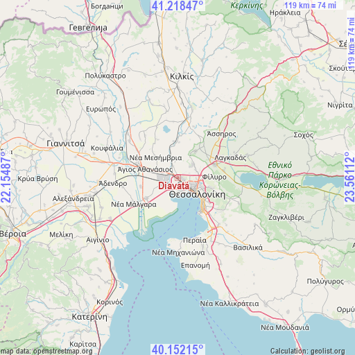
Diavatá GPS coordinates[2]
40° 41' 14.784" North, 22° 51' 28.764" East
| Map corner | latitude | longitude |
|---|---|---|
| Upper-left | 41.21847°, | 22.15487° |
| Center: | 40.68744°, | 22.85799° |
| Lower-right: | 40.15215°, | 23.56112° |
| Map W x H: | 118.6×118.6 km | = 73.7×73.7mi |
| max Lat: | 41.72048° ⇑19.2% North |
| Diavatá: | 40.68744° |
| min Lat: | ⇓80.8% South 34.8346° |
| min Long | Diavatá | max Long |
| 19.40494° | 22.85799° | 29.59361° |
| W 50.3%⇐ | ⇒49.7% E |
Elevation
Elevation of Diavatá is 15 m = 49 ft, and this is 153.9 m = 505 ft below average elevation for this country.
| Max E: |
1439 m = 4721 ft | 82.6% |
| Avg. | 168.9 m = 554 ft | |
| Diavatá | 15 m = 49 ft | |
Min E: |
0 m = 0 ft | 17.4% |
See also: Greece elevation on elevation.city.
Geographical zone
Diavatá is located in North temperate zone (between Tropic of Cancer and the Arctic Circle). Distance of this Northern Tropic circle is 1918.1 km =1191.9 mi to South.| Distance of | km | miles | from Diavatá |
|---|---|---|---|
| North Pole | 5483 | 3407 | to North |
| Arctic Circle | 2877.2 | 1787.8 | to North |
| Tropic Cancer | 1918.1 | 1191.9 | to South |
| Equator | 4524 | 2811.1 | to South |


Nearby cities:
15 places around Diavatá: (largest is in red/bold)
• Ampelókipoi
6.9 km =4.3 mi,  123°
123°
• Anchíalos
7.2 km =4.5 mi,  295°
295°
• Efkarpía
8.1 km =5 mi,  89°
89°
• Kalochóri
5.1 km =3.2 mi,  180°
180°
• Meneméni
4.6 km =2.9 mi,  134°
134°
• Neapoli
8 km =5 mi, 118°
• Neochoroúda
5.8 km =3.6 mi,  14°
14°
• Néa Magnisía
1 km =0.6 mi,  272°
272°
• Oraiókastro
6.9 km =4.3 mi,  45°
45°
• Pentálofos
6.2 km =3.9 mi,  355°
355°
• Políchni
8 km =5 mi,  106°
106°
• Stavroúpoli
7 km =4.3 mi, 106°
• Síndos
4.8 km =3 mi,  246°
246°
• Thessaloníki
7.8 km =4.8 mi, 128°
• Évosmos
4.6 km =2.9 mi, 113°
Sources, notices
• [Note1] Compared only with cities in Greece existing in our database
• [Src1] Map data: © OpenStreetMap contributors (CC-BY-SA)
• [Src2] Other city data from geonames.org with taken over terms of usage.
• [Src3] Geographical zone / Annual Mean Temperature by Robert A. Rohde @ Wikipedia
