Paralímni geodata
Paralímni (Central Macedonia) is a populated place; located in Greece in Europe/Athens (GMT+3) time zone. With population of 918 people, there are 1110 cities with bigger population in this country. Compared to other cities in Greece, 83.2% of cities are located further ↓South; 61.3% of cities are located further →East and 92.5% of cities have higher elevation than Paralímni. Note1


Paralímni GPS coordinates[2]
40° 45' 4.068" North, 22° 27' 14.76" East
| Map corner | latitude | longitude |
|---|---|---|
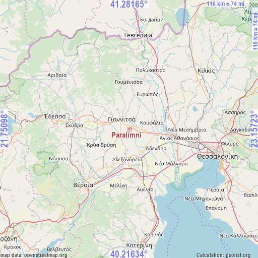
| Upper-left | 41.28165°, | 21.75098° |
| Center: | 40.75113°, | 22.4541° |
| Lower-right: | 40.21634°, | 23.15723° |
| Map W x H: | 118.5×118.4 km | = 73.6×73.6mi |
| max Lat: | 41.72048° ⇑16.8% North |
| Paralímni: | 40.75113° |
| min Lat: | ⇓83.2% South 34.8346° |
| min Long | Paralímni | max Long |
| 19.40494° | 22.4541° | 29.59361° |
| W 38.7%⇐ | ⇒61.3% E |
Elevation
Elevation of Paralímni is 7 m = 23 ft, and this is 161.9 m = 531 ft below average elevation for this country.
| Max E: |
1439 m = 4721 ft | 92.5% |
| Avg. | 168.9 m = 554 ft | |
| Paralímni | 7 m = 23 ft | |
Min E: |
0 m = 0 ft | 7.5% |
See also: Greece elevation on elevation.city.
Geographical zone
Paralímni is located in North temperate zone (between Tropic of Cancer and the Arctic Circle). Distance of this Northern Tropic circle is 1925.2 km =1196.3 mi to South.| Distance of | km | miles | from Paralímni |
|---|---|---|---|
| North Pole | 5476 | 3402.6 | to North |
| Arctic Circle | 2870.1 | 1783.4 | to North |
| Tropic Cancer | 1925.2 | 1196.3 | to South |
| Equator | 4531.1 | 2815.5 | to South |


Nearby cities:
15 places around Paralímni: (largest is in red/bold)
• Ampeleíes
10.8 km =6.7 mi,  328°
328°
• Axós
9.6 km =6 mi,  306°
306°
• Giannitsá
6 km =3.7 mi,  319°
319°
• Karyótissa
12 km =7.5 mi,  279°
279°
• Koufália
10.4 km =6.5 mi,  73°
73°
• Loudías
11 km =6.8 mi,  137°
137°
• Melíssi
8.9 km =5.5 mi,  286°
286°
• Mikró Monastíri
9 km =5.6 mi,  125°
125°
• Neochóri
9.6 km =6 mi,  184°
184°
• Néa Pélla
3.5 km =2.2 mi,  63°
63°
• Néos Mylótopos
11.2 km =7 mi, 311°
• Palaiós Mylótopos
12.2 km =7.6 mi,  298°
298°
• Pentaplátano
8.1 km =5 mi,  338°
338°
• Pélla
6.2 km =3.9 mi,  79°
79°
• Rachóna
9.8 km =6.1 mi,  46°
46°
Sources, notices
• [Note1] Compared only with cities in Greece existing in our database
• [Src1] Map data: © OpenStreetMap contributors (CC-BY-SA)
• [Src2] Other city data from geonames.org with taken over terms of usage.
• [Src3] Geographical zone / Annual Mean Temperature by Robert A. Rohde @ Wikipedia
