Koufália geodata
Koufália (Central Macedonia) is a seat of a third-order administrative division; located in Greece in Europe/Athens (GMT+3) time zone. With population of 8,305 people, there are 161 cities with bigger population in this country. Compared to other cities in Greece, 84.3% of cities are located further ↓South; 58% of cities are located further →East and 60.9% of cities have higher elevation than Koufália. Note1
Administrative division(s):
- Level 1: Central Macedonia
- Level 2: Nomós Thessaloníkis
- Level 3: Dimos Chalkidona


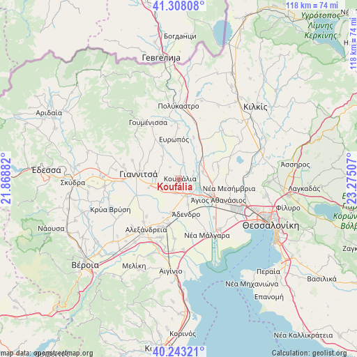
Koufália GPS coordinates[2]
40° 46' 40.008" North, 22° 34' 18.984" East
| Map corner | latitude | longitude |
|---|---|---|
| Upper-left | 41.30808°, | 21.86882° |
| Center: | 40.77778°, | 22.57194° |
| Lower-right: | 40.24321°, | 23.27507° |
| Map W x H: | 118.4×118.4 km | = 73.6×73.6mi |
| max Lat: | 41.72048° ⇑15.7% North |
| Koufália: | 40.77778° |
| min Lat: | ⇓84.3% South 34.8346° |
| min Long | Koufália | max Long |
| 19.40494° | 22.57194° | 29.59361° |
| W 42%⇐ | ⇒58% E |
Elevation
Elevation of Koufália is 47 m = 154 ft, and this is 121.9 m = 400 ft below average elevation for this country.
| Max E: |
1439 m = 4721 ft | 60.9% |
| Avg. | 168.9 m = 554 ft | |
| Koufália | 47 m = 154 ft | |
Min E: |
0 m = 0 ft | 39.1% |
See also: Greece elevation on elevation.city.
Geographical zone
Koufália is located in North temperate zone (between Tropic of Cancer and the Arctic Circle). Distance of this Northern Tropic circle is 1928.1 km =1198.1 mi to South.| Distance of | km | miles | from Koufália |
|---|---|---|---|
| North Pole | 5473 | 3400.8 | to North |
| Arctic Circle | 2867.1 | 1781.5 | to North |
| Tropic Cancer | 1928.1 | 1198.1 | to South |
| Equator | 4534.1 | 2817.4 | to South |


Nearby cities:
15 places around Koufália: (largest is in red/bold)
• Akropótamos
9.8 km =6.1 mi,  44°
44°
• Chalkidóna
5.6 km =3.5 mi,  155°
155°
• Eleoúsa
5.6 km =3.5 mi,  125°
125°
• Géfyra
11.4 km =7.1 mi,  116°
116°
• Kastanás
8.6 km =5.3 mi,  57°
57°
• Loudías
11.3 km =7 mi,  192°
192°
• Mikró Monastíri
8.6 km =5.3 mi,  197°
197°
• Néa Pélla
6.9 km =4.3 mi,  258°
258°
• Paralímni
10.4 km =6.5 mi,  253°
253°
• Parthéni
9.1 km =5.7 mi, 161°
• Próchoma
8.3 km =5.2 mi,  74°
74°
• Pélla
4.2 km =2.6 mi, 245°
• Rachóna
4.7 km =2.9 mi,  323°
323°
• Ágios Pétros
10 km =6.2 mi,  5°
5°
• Áthyra
5.7 km =3.5 mi,  18°
18°
Sources, notices
• [Note1] Compared only with cities in Greece existing in our database
• [Src1] Map data: © OpenStreetMap contributors (CC-BY-SA)
• [Src2] Other city data from geonames.org with taken over terms of usage.
• [Src3] Geographical zone / Annual Mean Temperature by Robert A. Rohde @ Wikipedia
