Asunción Mita geodata
Asunción Mita (Jutiapa) is a seat of a second-order administrative division; located in Guatemala in America/Guatemala (GMT-6) time zone. With population of 15,608 people, there are 78 cities with bigger population in this country. Compared to other cities in Guatemala, 90% of cities are located further ↑North; 91.2% of cities are located further ←West and 74.6% of cities have higher elevation than Asunción Mita. Note1


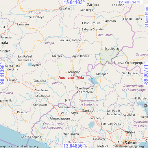
Asunción Mita GPS coordinates[2]
14° 19' 50.988" North, 89° 42' 38.988" West
| Map corner | latitude | longitude |
|---|---|---|
| Upper-left | 15.01103°, | -90.41396° |
| Center: | 14.33083°, | -89.71083° |
| Lower-right: | 13.64856°, | -89.00771° |
| Map W x H: | 151.5×151.5 km | = 94.1×94.1mi |
| max Lat: | 17.06606° ⇑90% North |
| Asunción Mita: | 14.33083° |
| min Lat: | ⇓10% South 13.9274° |
| min Long | Asunción Mita | max Long |
| -92.19298° | -89.71083° | -88.59444° |
| W 91.2%⇐ | ⇒8.8% E |
Elevation
Elevation of Asunción Mita is 476 m = 1562 ft, and this is 791 m = 2595 ft below average elevation for this country.
| Max E: |
3254 m = 10676 ft | 74.6% |
| Avg. | 1267 m = 4157 ft | |
| Asunción Mita | 476 m = 1562 ft | |
Min E: |
1 m = 3 ft | 25.4% |
See also: Guatemala elevation on elevation.city.
Geographical zone
Asunción Mita is located in North Torrid zone (between Equator and Tropic of Cancer). Distance of this Northern Tropic circle is 1012.5 km =629.1 mi to North.| Distance of | km | miles | from Asunción Mita |
|---|---|---|---|
| North Pole | 8413.6 | 5228 | to North |
| Arctic Circle | 5807.7 | 3608.7 | to North |
| Tropic Cancer | 1012.5 | 629.1 | to North |
| Equator | 1593.4 | 990.1 | to South |


Nearby cities:
15 places around Asunción Mita: (largest is in red/bold)
• Agua Blanca
19.9 km =12.4 mi,  19°
19°
• Atescatempa
17.7 km =11 mi,  191°
191°
• Comapa
32.5 km =20.2 mi,  222°
222°
• Concepción Las Minas
34.6 km =21.5 mi,  52°
52°
• El Adelanto
22.5 km =14 mi, 215°
• El Progreso
15.1 km =9.4 mi,  278°
278°
• Ipala
33.4 km =20.8 mi, 17°
• Jerez
26 km =16.2 mi, 189°
• Jutiapa
20.4 km =12.7 mi,  257°
257°
• Monjas
25.2 km =15.7 mi,  318°
318°
• San Luis Jilotepeque
35.6 km =22.1 mi,  356°
356°
• San Manuel Chaparrón
21.5 km =13.4 mi,  343°
343°
• Santa Catarina Mita
13.9 km =8.6 mi, 342°
• Yupiltepeque
16.5 km =10.3 mi,  208°
208°
• Zapotitlán
25.6 km =15.9 mi, 211°
Sources, notices
• [Note1] Compared only with cities in Guatemala existing in our database
• [Src1] Map data: © OpenStreetMap contributors (CC-BY-SA)
• [Src2] Other city data from geonames.org with taken over terms of usage.
• [Src3] Geographical zone / Annual Mean Temperature by Robert A. Rohde @ Wikipedia
