Monjas geodata
Monjas (Jalapa) is a seat of a second-order administrative division; located in Guatemala in America/Guatemala (GMT-6) time zone. With population of 10,351 people, there are 122 cities with bigger population in this country. Compared to other cities in Guatemala, 82.9% of cities are located further ↑North; 85.5% of cities are located further ←West and 59.9% of cities have higher elevation than Monjas. Note1


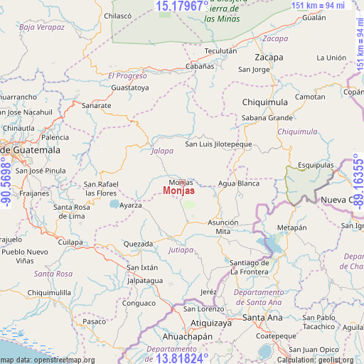
Monjas GPS coordinates[2]
14° 30' 0" North, 89° 52' 0.012" West
| Map corner | latitude | longitude |
|---|---|---|
| Upper-left | 15.17967°, | -90.5698° |
| Center: | 14.5°, | -89.86667° |
| Lower-right: | 13.81824°, | -89.16355° |
| Map W x H: | 151.4×151.4 km | = 94.1×94.1mi |
| max Lat: | 17.06606° ⇑82.9% North |
| Monjas: | 14.5° |
| min Lat: | ⇓17.1% South 13.9274° |
| min Long | Monjas | max Long |
| -92.19298° | -89.86667° | -88.59444° |
| W 85.5%⇐ | ⇒14.5% E |
Elevation
Elevation of Monjas is 956 m = 3136 ft, and this is 311 m = 1020 ft below average elevation for this country.
| Max E: |
3254 m = 10676 ft | 59.9% |
| Avg. | 1267 m = 4157 ft | |
| Monjas | 956 m = 3136 ft | |
Min E: |
1 m = 3 ft | 40.1% |
See also: Guatemala elevation on elevation.city.
Geographical zone
Monjas is located in North Torrid zone (between Equator and Tropic of Cancer). Distance of this Northern Tropic circle is 993.7 km =617.5 mi to North.| Distance of | km | miles | from Monjas |
|---|---|---|---|
| North Pole | 8394.8 | 5216.3 | to North |
| Arctic Circle | 5788.9 | 3597.1 | to North |
| Tropic Cancer | 993.7 | 617.5 | to North |
| Equator | 1612.2 | 1001.8 | to South |


Nearby cities:
15 places around Monjas: (largest is in red/bold)
• Agua Blanca
23.3 km =14.5 mi,  90°
90°
• Asunción Mita
25.2 km =15.7 mi,  138°
138°
• El Progreso
16.8 km =10.4 mi,  173°
173°
• Ipala
29.9 km =18.6 mi,  64°
64°
• Jalapa
19.9 km =12.4 mi,  318°
318°
• Jutiapa
23.4 km =14.5 mi,  187°
187°
• Mataquescuintla
34.3 km =21.3 mi,  275°
275°
• Quesada
31.7 km =19.7 mi,  216°
216°
• San Carlos Alzatate
20.8 km =12.9 mi,  269°
269°
• San Diego
32.8 km =20.4 mi,  15°
15°
• San Luis Jilotepeque
22 km =13.7 mi,  40°
40°
• San Manuel Chaparrón
10.9 km =6.8 mi,  80°
80°
• San Pedro Pinula
18.6 km =11.6 mi,  5°
5°
• San Rafael Las Flores
33.7 km =20.9 mi, 265°
• Santa Catarina Mita
13.7 km =8.5 mi,  113°
113°
Sources, notices
• [Note1] Compared only with cities in Guatemala existing in our database
• [Src1] Map data: © OpenStreetMap contributors (CC-BY-SA)
• [Src2] Other city data from geonames.org with taken over terms of usage.
• [Src3] Geographical zone / Annual Mean Temperature by Robert A. Rohde @ Wikipedia
