Atescatempa geodata
Atescatempa (Jutiapa) is a seat of a second-order administrative division; located in Guatemala in America/Guatemala (GMT-6) time zone. With population of 11,543 people, there are 109 cities with bigger population in this country. Compared to other cities in Guatemala, 95.6% of cities are located further ↑North; 90% of cities are located further ←West and 69% of cities have higher elevation than Atescatempa. Note1


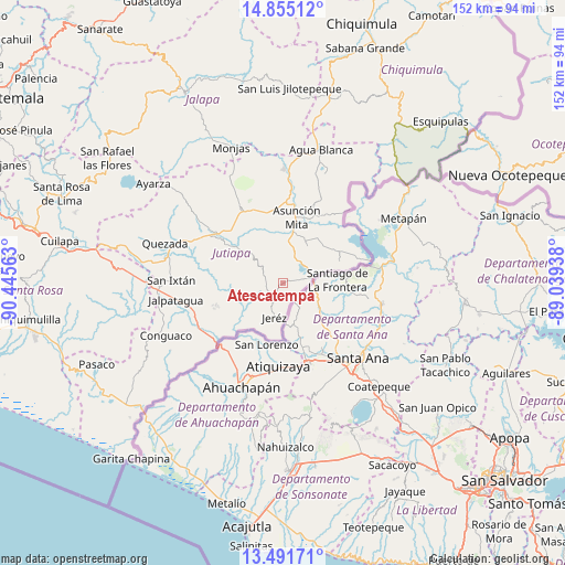
Atescatempa GPS coordinates[2]
14° 10' 27.984" North, 89° 44' 33" West
| Map corner | latitude | longitude |
|---|---|---|
| Upper-left | 14.85512°, | -90.44563° |
| Center: | 14.17444°, | -89.7425° |
| Lower-right: | 13.49171°, | -89.03938° |
| Map W x H: | 151.6×151.6 km | = 94.2×94.2mi |
| max Lat: | 17.06606° ⇑95.6% North |
| Atescatempa: | 14.17444° |
| min Lat: | ⇓4.4% South 13.9274° |
| min Long | Atescatempa | max Long |
| -92.19298° | -89.7425° | -88.59444° |
| W 90%⇐ | ⇒10% E |
Elevation
Elevation of Atescatempa is 684 m = 2244 ft, and this is 583 m = 1913 ft below average elevation for this country.
| Max E: |
3254 m = 10676 ft | 69% |
| Avg. | 1267 m = 4157 ft | |
| Atescatempa | 684 m = 2244 ft | |
Min E: |
1 m = 3 ft | 31% |
See also: Guatemala elevation on elevation.city.
Geographical zone
Atescatempa is located in North Torrid zone (between Equator and Tropic of Cancer). Distance of this Northern Tropic circle is 1029.9 km =639.9 mi to North.| Distance of | km | miles | from Atescatempa |
|---|---|---|---|
| North Pole | 8431 | 5238.8 | to North |
| Arctic Circle | 5825.1 | 3619.5 | to North |
| Tropic Cancer | 1029.9 | 639.9 | to North |
| Equator | 1576 | 979.3 | to South |


Nearby cities:
15 places around Atescatempa: (largest is in red/bold)
• Agua Blanca
37.5 km =23.3 mi,  15°
15°
• Asunción Mita
17.7 km =11 mi,  11°
11°
• Comapa
19.8 km =12.3 mi,  251°
251°
• Conguaco
34.3 km =21.3 mi, 245°
• El Adelanto
9.8 km =6.1 mi,  264°
264°
• El Progreso
22.7 km =14.1 mi,  329°
329°
• Jalpatagua
28.9 km =18 mi, 262°
• Jerez
8.3 km =5.2 mi,  185°
185°
• Jutiapa
21 km =13 mi,  308°
308°
• Monjas
38.6 km =24 mi,  339°
339°
• Quesada
33.8 km =21 mi,  288°
288°
• San Manuel Chaparrón
38.1 km =23.7 mi,  356°
356°
• Santa Catarina Mita
30.7 km =19.1 mi, 358°
• Yupiltepeque
5.2 km =3.2 mi,  302°
302°
• Zapotitlán
10.8 km =6.7 mi,  244°
244°
Sources, notices
• [Note1] Compared only with cities in Guatemala existing in our database
• [Src1] Map data: © OpenStreetMap contributors (CC-BY-SA)
• [Src2] Other city data from geonames.org with taken over terms of usage.
• [Src3] Geographical zone / Annual Mean Temperature by Robert A. Rohde @ Wikipedia
