Agua Blanca geodata
Agua Blanca (Jutiapa) is a seat of a second-order administrative division; located in Guatemala in America/Guatemala (GMT-6) time zone. With population of 2,776 people, there are 247 cities with bigger population in this country. Compared to other cities in Guatemala, 82.9% of cities are located further ↑North; 92% of cities are located further ←West and 63.4% of cities have higher elevation than Agua Blanca. Note1


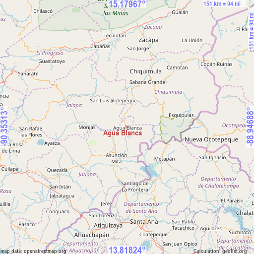
Agua Blanca GPS coordinates[2]
14° 30' 0" North, 89° 39' 0" West
| Map corner | latitude | longitude |
|---|---|---|
| Upper-left | 15.17967°, | -90.35313° |
| Center: | 14.5°, | -89.65° |
| Lower-right: | 13.81824°, | -88.94688° |
| Map W x H: | 151.4×151.4 km | = 94.1×94.1mi |
| max Lat: | 17.06606° ⇑82.9% North |
| Agua Blanca: | 14.5° |
| min Lat: | ⇓17.1% South 13.9274° |
| min Long | Agua Blanca | max Long |
| -92.19298° | -89.65° | -88.59444° |
| W 92%⇐ | ⇒8% E |
Elevation
Elevation of Agua Blanca is 892 m = 2927 ft, and this is 375 m = 1230 ft below average elevation for this country.
| Max E: |
3254 m = 10676 ft | 63.4% |
| Avg. | 1267 m = 4157 ft | |
| Agua Blanca | 892 m = 2927 ft | |
Min E: |
1 m = 3 ft | 36.6% |
See also: Guatemala elevation on elevation.city.
Geographical zone
Agua Blanca is located in North Torrid zone (between Equator and Tropic of Cancer). Distance of this Northern Tropic circle is 993.7 km =617.5 mi to North.| Distance of | km | miles | from Agua Blanca |
|---|---|---|---|
| North Pole | 8394.8 | 5216.3 | to North |
| Arctic Circle | 5788.9 | 3597.1 | to North |
| Tropic Cancer | 993.7 | 617.5 | to North |
| Equator | 1612.2 | 1001.8 | to South |


Nearby cities:
15 places around Agua Blanca: (largest is in red/bold)
• Asunción Mita
19.9 km =12.4 mi,  199°
199°
• Chiquimula
35.2 km =21.9 mi,  18°
18°
• Concepción Las Minas
20.9 km =13 mi,  83°
83°
• El Progreso
27.2 km =16.9 mi,  232°
232°
• Esquipulas
32.9 km =20.4 mi, 77°
• Ipala
13.5 km =8.4 mi, 15°
• Monjas
23.3 km =14.5 mi,  270°
270°
• Quezaltepeque
26.9 km =16.7 mi,  55°
55°
• San Diego
34.6 km =21.5 mi,  335°
335°
• San Jacinto
24.6 km =15.3 mi,  41°
41°
• San José La Arada
25.1 km =15.6 mi, 16°
• San Luis Jilotepeque
18.9 km =11.7 mi,  331°
331°
• San Manuel Chaparrón
12.7 km =7.9 mi,  278°
278°
• San Pedro Pinula
28.4 km =17.6 mi,  310°
310°
• Santa Catarina Mita
12.1 km =7.5 mi,  242°
242°
Sources, notices
• [Note1] Compared only with cities in Guatemala existing in our database
• [Src1] Map data: © OpenStreetMap contributors (CC-BY-SA)
• [Src2] Other city data from geonames.org with taken over terms of usage.
• [Src3] Geographical zone / Annual Mean Temperature by Robert A. Rohde @ Wikipedia
