Puerto Cortez geodata
Puerto Cortez (Cortés) is a populated place; located in Honduras in America/Tegucigalpa (GMT-6) time zone. With population of 48,013 people, there are 7 cities with bigger population in this country. Compared to other cities in Honduras, 96.8% of cities are located further ↓South; 61.6% of cities are located further →East and 95.2% of cities have higher elevation than Puerto Cortez. Note1


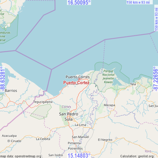
Puerto Cortez GPS coordinates[2]
15° 49' 32.232" North, 87° 55' 46.848" West
| Map corner | latitude | longitude |
|---|---|---|
| Upper-left | 16.50095°, | -88.63281° |
| Center: | 15.82562°, | -87.92968° |
| Lower-right: | 15.14803°, | -87.22656° |
| Map W x H: | 150.4×150.4 km | = 93.5×93.5mi |
| max Lat: | 16.45° ⇑3.2% North |
| Puerto Cortez: | 15.82562° |
| min Lat: | ⇓96.8% South 13.11667° |
| min Long | Puerto Cortez | max Long |
| -89.23333° | -87.92968° | -83.23333° |
| W 38.4%⇐ | ⇒61.6% E |
Elevation
Elevation of Puerto Cortez is 10 m = 33 ft, and this is 551.2 m = 1808 ft below average elevation for this country.
| Max E: |
1811 m = 5942 ft | 95.2% |
| Avg. | 561.2 m = 1841 ft | |
| Puerto Cortez | 10 m = 33 ft | |
Min E: |
1 m = 3 ft | 4.8% |
See also: Puerto Cortez elevation on elevation.city.
Geographical zone
Puerto Cortez is located in North Torrid zone (between Equator and Tropic of Cancer). Distance of this Northern Tropic circle is 846.3 km =525.9 mi to North.| Distance of | km | miles | from Puerto Cortez |
|---|---|---|---|
| North Pole | 8247.4 | 5124.7 | to North |
| Arctic Circle | 5641.5 | 3505.5 | to North |
| Tropic Cancer | 846.3 | 525.9 | to North |
| Equator | 1759.6 | 1093.4 | to South |


Nearby cities:
15 places around Puerto Cortez: (largest is in red/bold)
• Baja Mar
10.6 km =6.6 mi,  48°
48°
• Baracoa
10.8 km =6.7 mi,  127°
127°
• Chivana
10.2 km =6.3 mi,  214°
214°
• Choloma
23.6 km =14.7 mi,  186°
186°
• Cuyamel
33.9 km =21.1 mi,  238°
238°
• El Porvenir
0.9 km =0.6 mi,  335°
335°
• El Rancho
17.8 km =11.1 mi, 187°
• La Huesa
27.4 km =17 mi,  169°
169°
• La Jutosa
22.7 km =14.1 mi,  199°
199°
• Monterrey
27.4 km =17 mi, 169°
• Omoa
12.9 km =8 mi, 239°
• Puerto Alto
15.5 km =9.6 mi,  154°
154°
• Quebrada Seca
17.8 km =11.1 mi, 187°
• Río Blanquito
10.7 km =6.6 mi,  162°
162°
• Travesía
5.6 km =3.5 mi,  34°
34°
Sources, notices
• [Note1] Compared only with cities in Honduras existing in our database
• [Src1] Map data: © OpenStreetMap contributors (CC-BY-SA)
• [Src2] Other city data from geonames.org with taken over terms of usage.
• [Src3] Geographical zone / Annual Mean Temperature by Robert A. Rohde @ Wikipedia
