Choloma geodata
Choloma (Cortés) is a populated place; located in Honduras in America/Tegucigalpa (GMT-6) time zone. With population of 139,100 people, there are 2 cities with bigger population in this country. Compared to other cities in Honduras, 88.2% of cities are located further ↓South; 64% of cities are located further →East and 85.8% of cities have higher elevation than Choloma. Note1


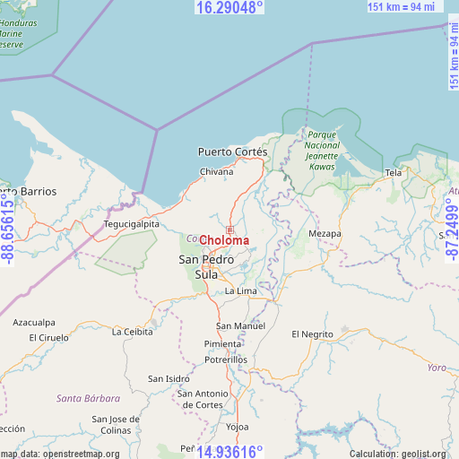
Choloma GPS coordinates[2]
15° 36' 51.984" North, 87° 57' 10.872" West
| Map corner | latitude | longitude |
|---|---|---|
| Upper-left | 16.29048°, | -88.65615° |
| Center: | 15.61444°, | -87.95302° |
| Lower-right: | 14.93616°, | -87.2499° |
| Map W x H: | 150.6×150.6 km | = 93.6×93.6mi |
| max Lat: | 16.45° ⇑11.8% North |
| Choloma: | 15.61444° |
| min Lat: | ⇓88.2% South 13.11667° |
| min Long | Choloma | max Long |
| -89.23333° | -87.95302° | -83.23333° |
| W 36%⇐ | ⇒64% E |
Elevation
Elevation of Choloma is 41 m = 135 ft, and this is 520.2 m = 1707 ft below average elevation for this country.
| Max E: |
1811 m = 5942 ft | 85.8% |
| Avg. | 561.2 m = 1841 ft | |
| Choloma | 41 m = 135 ft | |
Min E: |
1 m = 3 ft | 14.2% |
See also: Choloma elevation on elevation.city.
Geographical zone
Choloma is located in North Torrid zone (between Equator and Tropic of Cancer). Distance of this Northern Tropic circle is 869.8 km =540.5 mi to North.| Distance of | km | miles | from Choloma |
|---|---|---|---|
| North Pole | 8270.9 | 5139.3 | to North |
| Arctic Circle | 5665 | 3520.1 | to North |
| Tropic Cancer | 869.8 | 540.5 | to North |
| Equator | 1736.2 | 1078.8 | to South |


Nearby cities:
15 places around Choloma: (largest is in red/bold)
• Armenta
16.4 km =10.2 mi,  219°
219°
• Chivana
15.4 km =9.6 mi,  347°
347°
• El Rancho
5.8 km =3.6 mi,  3°
3°
• El Zapotal del Norte
15 km =9.3 mi, 223°
• La Huesa
8.2 km =5.1 mi,  114°
114°
• La Jutosa
5.5 km =3.4 mi,  292°
292°
• Monterrey
8.2 km =5.1 mi, 114°
• Omoa
19 km =11.8 mi,  333°
333°
• Peña Blanca
13.8 km =8.6 mi,  229°
229°
• Puerto Alto
13.3 km =8.3 mi,  44°
44°
• Quebrada Seca
5.8 km =3.6 mi, 3°
• Río Blanquito
14.4 km =8.9 mi,  23°
23°
• San José del Boquerón
17.3 km =10.7 mi,  147°
147°
• San Pedro Sula
14.5 km =9 mi,  212°
212°
• Victoria
18.3 km =11.4 mi,  132°
132°
Sources, notices
• [Note1] Compared only with cities in Honduras existing in our database
• [Src1] Map data: © OpenStreetMap contributors (CC-BY-SA)
• [Src2] Other city data from geonames.org with taken over terms of usage.
• [Src3] Geographical zone / Annual Mean Temperature by Robert A. Rohde @ Wikipedia
