Travesía geodata
Travesía (Cortés) is a populated place; located in Honduras in America/Tegucigalpa (GMT-6) time zone. With population of 1,283 people, there are 298 cities with bigger population in this country. Compared to other cities in Honduras, 97.8% of cities are located further ↓South; 60.8% of cities are located further →East and 97.8% of cities have higher elevation than Travesía. Note1


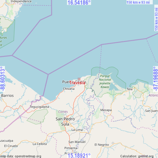
Travesía GPS coordinates[2]
15° 52' 0.012" North, 87° 54' 0" West
| Map corner | latitude | longitude |
|---|---|---|
| Upper-left | 16.54186°, | -88.60313° |
| Center: | 15.86667°, | -87.9° |
| Lower-right: | 15.18921°, | -87.19688° |
| Map W x H: | 150.4×150.4 km | = 93.5×93.5mi |
| max Lat: | 16.45° ⇑2.2% North |
| Travesía: | 15.86667° |
| min Lat: | ⇓97.8% South 13.11667° |
| min Long | Travesía | max Long |
| -89.23333° | -87.9° | -83.23333° |
| W 39.2%⇐ | ⇒60.8% E |
Elevation
Elevation of Travesía is 6 m = 20 ft, and this is 555.2 m = 1822 ft below average elevation for this country.
| Max E: |
1811 m = 5942 ft | 97.8% |
| Avg. | 561.2 m = 1841 ft | |
| Travesía | 6 m = 20 ft | |
Min E: |
1 m = 3 ft | 2.2% |
See also: Honduras elevation on elevation.city.
Geographical zone
Travesía is located in North Torrid zone (between Equator and Tropic of Cancer). Distance of this Northern Tropic circle is 841.7 km =523 mi to North.| Distance of | km | miles | from Travesía |
|---|---|---|---|
| North Pole | 8242.9 | 5121.9 | to North |
| Arctic Circle | 5637 | 3502.7 | to North |
| Tropic Cancer | 841.7 | 523 | to North |
| Equator | 1764.2 | 1096.2 | to South |


Nearby cities:
15 places around Travesía: (largest is in red/bold)
• Baja Mar
5.3 km =3.3 mi,  62°
62°
• Baracoa
12.3 km =7.6 mi,  154°
154°
• Chivana
15.7 km =9.8 mi,  214°
214°
• Choloma
28.6 km =17.8 mi,  191°
191°
• Cuyamel
39.1 km =24.3 mi,  235°
235°
• El Porvenir
5.1 km =3.2 mi,  223°
223°
• El Rancho
22.9 km =14.2 mi, 193°
• La Huesa
31.6 km =19.6 mi,  176°
176°
• La Jutosa
28.1 km =17.5 mi,  202°
202°
• Monterrey
31.6 km =19.6 mi, 176°
• Omoa
18.1 km =11.2 mi,  232°
232°
• Puerto Alto
18.9 km =11.7 mi,  169°
169°
• Puerto Cortez
5.6 km =3.5 mi, 214°
• Quebrada Seca
22.9 km =14.2 mi, 193°
• Río Blanquito
14.8 km =9.2 mi, 180°
Sources, notices
• [Note1] Compared only with cities in Honduras existing in our database
• [Src1] Map data: © OpenStreetMap contributors (CC-BY-SA)
• [Src2] Other city data from geonames.org with taken over terms of usage.
• [Src3] Geographical zone / Annual Mean Temperature by Robert A. Rohde @ Wikipedia
