Zopilotepe geodata
Zopilotepe (Olancho) is a populated place; located in Honduras in America/Tegucigalpa (GMT-6) time zone. With population of 1,300 people, there are 293 cities with bigger population in this country. Compared to other cities in Honduras, 66.8% of cities are located further ↑North; 90.2% of cities are located further ←West and 60.2% of cities have higher elevation than Zopilotepe. Note1


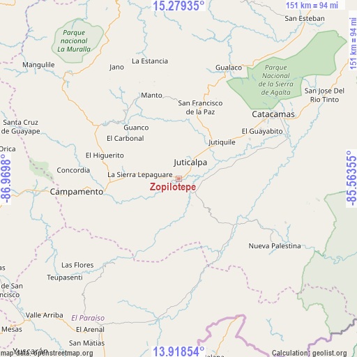
Zopilotepe GPS coordinates[2]
14° 36' 0" North, 86° 16' 0.012" West
| Map corner | latitude | longitude |
|---|---|---|
| Upper-left | 15.27935°, | -86.9698° |
| Center: | 14.6°, | -86.26667° |
| Lower-right: | 13.91854°, | -85.56355° |
| Map W x H: | 151.3×151.3 km | = 94×94mi |
| max Lat: | 16.45° ⇑66.8% North |
| Zopilotepe: | 14.6° |
| min Lat: | ⇓33.2% South 13.11667° |
| min Long | Zopilotepe | max Long |
| -89.23333° | -86.26667° | -83.23333° |
| W 90.2%⇐ | ⇒9.8% E |
Elevation
Elevation of Zopilotepe is 394 m = 1293 ft, and this is 167.2 m = 549 ft below average elevation for this country.
| Max E: |
1811 m = 5942 ft | 60.2% |
| Avg. | 561.2 m = 1841 ft | |
| Zopilotepe | 394 m = 1293 ft | |
Min E: |
1 m = 3 ft | 39.8% |
See also: Honduras elevation on elevation.city.
Geographical zone
Zopilotepe is located in North Torrid zone (between Equator and Tropic of Cancer). Distance of this Northern Tropic circle is 982.6 km =610.6 mi to North.| Distance of | km | miles | from Zopilotepe |
|---|---|---|---|
| North Pole | 8383.7 | 5209.4 | to North |
| Arctic Circle | 5777.8 | 3590.2 | to North |
| Tropic Cancer | 982.6 | 610.6 | to North |
| Equator | 1623.4 | 1008.7 | to South |


Nearby cities:
15 places around Zopilotepe: (largest is in red/bold)
• Arimís
35.2 km =21.9 mi,  54°
54°
• El Guayabito
36.1 km =22.4 mi,  44°
44°
• El Rusio
18.3 km =11.4 mi,  215°
215°
• Guarizama
35.9 km =22.3 mi,  348°
348°
• Juticalpa
9 km =5.6 mi,  34°
34°
• Jutiquile
23.6 km =14.7 mi,  56°
56°
• La Concepción
11.7 km =7.3 mi,  17°
17°
• La Empalizada
15.4 km =9.6 mi,  68°
68°
• Laguna Seca
21.1 km =13.1 mi, 58°
• Manto
37.4 km =23.2 mi,  340°
340°
• Punuare
35.5 km =22.1 mi, 65°
• Sabana Abajo
34.1 km =21.2 mi,  270°
270°
• San Francisco de Becerra
18.3 km =11.4 mi,  78°
78°
• San Francisco de la Paz
34.1 km =21.2 mi,  12°
12°
• San Nicolás
5.8 km =3.6 mi,  162°
162°
Sources, notices
• [Note1] Compared only with cities in Honduras existing in our database
• [Src1] Map data: © OpenStreetMap contributors (CC-BY-SA)
• [Src2] Other city data from geonames.org with taken over terms of usage.
• [Src3] Geographical zone / Annual Mean Temperature by Robert A. Rohde @ Wikipedia
