San Francisco de la Paz geodata
San Francisco de la Paz (Olancho) is a populated place; located in Honduras in America/Tegucigalpa (GMT-6) time zone. With population of 5,411 people, there are 57 cities with bigger population in this country. Compared to other cities in Honduras, 50.8% of cities are located further ↓South; 91.2% of cities are located further ←West and 59.2% of cities have lower elevation than San Francisco de la Paz. Note1
Current local time in San Francisco de la Paz:
06:27 PM, SundayDifference from your time zone: hours


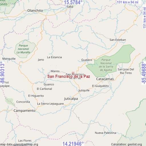
San Francisco de la Paz GPS coordinates[2]
14° 54' 0" North, 86° 12' 0" West
| Map corner | latitude | longitude |
|---|---|---|
| Upper-left | 15.5784°, | -86.90313° |
| Center: | 14.9°, | -86.2° |
| Lower-right: | 14.21946°, | -85.49688° |
| Map W x H: | 151.1×151.1 km | = 93.9×93.9mi |
| max Lat: | 16.45° ⇑49.2% North |
| San Francisco de la Paz: | 14.9° |
| min Lat: | ⇓50.8% South 13.11667° |
| min Long | San Francisco d | max Long |
| -89.23333° | -86.2° | -83.23333° |
| W 91.2%⇐ | ⇒8.8% E |
Elevation
Elevation of San Francisco de la Paz is 667 m = 2188 ft, and this is 105.8 m = 347 ft above average elevation for this country.
| Max E: |
1811 m = 5942 ft | 40.8% |
| San Francisco de la Paz | 667 m 2188 ft | |
| Avg. | 561.2 m = 1841 ft | |
Min E: |
1 m = 3 ft | 59.2% |
See also: Honduras elevation on elevation.city.
Geographical zone
San Francisco de la Paz is located in North Torrid zone (between Equator and Tropic of Cancer). Distance of this Northern Tropic circle is 949.2 km =589.8 mi to North.| Distance of | km | miles | from San Francisco de la Paz |
|---|---|---|---|
| North Pole | 8350.3 | 5188.6 | to North |
| Arctic Circle | 5744.4 | 3569.4 | to North |
| Tropic Cancer | 949.2 | 589.8 | to North |
| Equator | 1656.7 | 1029.4 | to South |


Nearby cities:
15 places around San Francisco de la Paz: (largest is in red/bold)
• Arimís
25.1 km =15.6 mi,  121°
121°
• El Guayabito
19.4 km =12.1 mi,  112°
112°
• Gualaco
19.7 km =12.2 mi,  44°
44°
• Guarizama
14.4 km =8.9 mi,  277°
277°
• Juticalpa
26 km =16.2 mi,  184°
184°
• Jutiquile
23.9 km =14.9 mi,  148°
148°
• La Concepción
22.5 km =14 mi,  189°
189°
• La Empalizada
28.7 km =17.8 mi,  165°
165°
• La Estancia
23.2 km =14.4 mi,  315°
315°
• La Guata
28.3 km =17.6 mi, 315°
• Laguna Seca
24.7 km =15.3 mi, 154°
• Manto
19.8 km =12.3 mi, 275°
• Punuare
31.2 km =19.4 mi,  126°
126°
• San Francisco de Becerra
31.5 km =19.6 mi,  160°
160°
• Santa María del Real
30.7 km =19.1 mi, 118°
Sources, notices
• [Note1] Compared only with cities in Honduras existing in our database
• [Src1] Map data: © OpenStreetMap contributors (CC-BY-SA)
• [Src2] Other city data from geonames.org with taken over terms of usage.
• [Src3] Geographical zone / Annual Mean Temperature by Robert A. Rohde @ Wikipedia
